Quantcast
Channel: Aircrash Sites – Paul Shorrock – One Man's Mountains AKA One Pillock's Hillocks
Viewing all 23 articles
Browse latest View live

#45 – Wide open spaces! – Whitendale in the Forest of Bowland

$
0
0

Wide open spaces above Whitendale

If you like your spaces to be ‘wide open’ ones, you could do a lot worse than the Forest of Bowland, a tiny bit of wildness tucked away between Lancaster and the Yorkshire Dales.  Go expecting trees and you will be disappointed, as it’s an ancient hunting forest.  Instead, expect to find empty peat moors with isolated gritstone edges.  It’s not particularly pretty (though it does have a wild grandeur) and there’s little drama.  For me, though, these are the hills of home.

Above Wood House Lane heading towards Dunsop Fell

I had really enjoyed last weeks visit to the north of the Peak District, as it reminded me of my earliest hill-walking days.  In my early teens I cycled with my mate Sam to the hills near Dunsop Bridge – Sam was keen on birds (feathered ones, but we were only 13 at the time!) and he wanted to look at a gull colony on the high moors.  We biked about twenty miles then started walking.  At the time I hadn’t a clue where we were going, and neither I suspect did Sam, though I can now trace the route on the map.

On Dunsop Fell

One thing I do remember about that trip, though, is not wanting to turn back – I just wanted to carry on, to see what was over the next horizon.  I’ve been doing that ever since.  I suppose it’s what you call a ‘life changing moment’.

The descent to Whitendale

My early wanderings were mostly in the southern part of Bowland, and I hadn’t returned to the northern bit since that trip with Sam – well, there’s a limit to how far you can explore when you’re 13 and using a bike to get to the hills.  By the time I had a driving licence I wanted to visit bigger and more dramatic hills, so despite the fact that the hills of Bowland are the hills of home, there remain sections that I have never walked.

Looking down the track leading to isolated Whitendale Farm – a long way to the shops!

It was about time I returned to unfinished business in Bowland, so Chris and I (and t’dog of course) set off to Slaidburn to fill in a gap in my Bowland experience.  We started up over Dunsop Fell, heading for the lonely farm at Whitendale, a short distance but over typical gritstone moors – a combination of peat and water!

Whitendale Farm

Neat stone walling

From above, Whitendale farm looked incredibly tidy and well kept, an impression reinforced on arrival by some of the neatest drystone walls I have seen.  From there we set our course to continue up the valley of the Whitendale River, heading for the Hornby Road.

Remains of an old tree in the Whitendale Valley

Approaching the Hornby Road, with the Whitendale Valley behind

The Hornby Road is an ancient track over the moors between Slaidburn and Hornby, and is sometimes known by the alternative name of the Salt Road or Salter Road, a reference to its previous history as a packhorse route used to transport salt.  The route is much older than that, however, and the section we walked was part of the Roman road network linking the important military bases of Ribchester and Carlisle

The Hornby Road

In fact, these quiet hills are full of history, some ancient and some less so.  Our route on Hornby Road was less than 1 kilometre from the site of an aircraft crash on Baxton Fell on 26 January 1943, following the collision of two American P38 fighters flying to Northern Ireland to be modified for desert conditions – the second aircraft crashed on Dunsop Fell near to our outward route.  Both pilots were killed in the accident.

Hornby Road at Croasdale Fell

Old instincts surfaced on this section of the walk.  ‘Mist’, our Border Collie, is trained to be safe near sheep, cattle and horses, but a couple of hundred years of selective breeding by shepherds leaves a legacy, and several times she went into an instinctive ‘collie crouch’, giving the sheep ‘eye’ – the sheep, likewise, obeyed an older instinct to herd together when faced by a ‘wolf’!  A quick word of command reminded the dog that her herding instincts are now redundant.

The sheep following an ancient instinct

‘Mist’ doing likewise

We followed this section of the Hornby Road for about five kilometres, allowing rapid progress, especially when compared with our outward route picking a way through the peat bogs of Dunsop Fell.  Before long we were back at the waiting car, ready to rejoin the modern world again.

p.s.  Busy week this week (hopefully!)  Good weather forecast, and we’re in North Wales.  I’m hoping to knock off a couple more routes for the Snowdonia Guide for Discovery Walking Guides – the only cloud on an otherwise cloudless horizon is a knee injury that has been a nuisance for the last few days, so I’m travelling hopefully!

Text and images © Paul Shorrock


Filed under: 4. Northern England, Aircrash Sites, Border Collies Tagged: Border Collie, Discovery Walking Guides, Forest of Bowland, hillwalking, Lancashire

#151 – Carneddau air-crash, Craig yr Ysfa

$
0
0
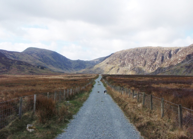
The walk in to Cwm Eigiau and Craig yr Ysfa

The walk in to Cwm Eigiau and Craig yr Ysfa

It was a strange kind of winter in North Wales this year. We ‘hardy mountain types’  :-) like to get out to play in the snow, but the snow was erratic, never hanging around for long – when it did hang around, it was usually ‘blowing a hoolie’, and on one trip out I could barely stand upright. Then, one April day, the wind dropped.

Heading into the valley of Cwm Eigiau, with Pen yr Helgi Du ahead

Heading into the valley of Cwm Eigiau, with Pen yr Helgi Du ahead

A little further on, with Craig yr Ysfa coming into view on the right

A little further on, with Craig yr Ysfa coming into view on the right

I’ve developed a bit of an obsession with the mountains of the Carneddau. In my younger days when a trip to the Welsh mountains was a rare treat, I used to go for the classic routes such as the Snowdon Horseshoe or the North Ridge of Tryfan with the continuation up Bristly Ridge. Now I live just an hour away, I have time to explore a bit more off the beaten track.

Heading for Craig yr Ysfa

Heading for Craig yr Ysfa

Off the beaten track sums it up nicely – the mountains of the Carneddau are like a miniature version of the Cairngorms in the Scottish Highlands. They are wild and untamed, and often a navigation trap for the unwary. Just the kind of place where you can wander and explore freely.

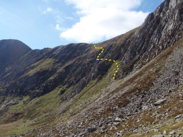
The intended route to Bwlch Eryl Farchog

The intended route to Bwlch Eryl Farchog

My route (with the original Bwlch Eryl Farchog option shown in blue)

My route (with the original Bwlch Eryl Farchog option shown in blue)

I had a plan, sort of ….    I would follow the quiet valley of Cwm Eigiau, then try to find the airy path on the left side of Craig yr Ysfa, that works its way up to the col of Bwlch Eryl Farchog. From there I would head for Carnedd Llewelyn and Foel Grach before heading back to the car. That was the plan ….

Engine from the Blenheim crash, April 1940

Engine from the Blenheim crash, April 1940

I had read about a wartime air-crash on Craig yr Ysfa, and decided that, as I was in the right area, I would look for one of the engines. Although the colours of the metal are starting to blend in with the rocks, it didn’t take much effort to find it, and as I looked at this relic of almost 75 years ago, I thought of the young men who had died in the crash.

* * *

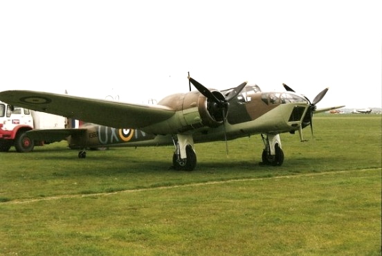
Bristol Blenheim aircraft

Bristol Blenheim aircraft

On 8th April 1940, three Blenheim aircraft left RAF Bicester on a cross-country training flight to RAF Ronaldsway on the Isle of Man. On the approach to the mountains of the Carneddau, Blenheim L9039 broke from the formation in cloud, and at 1120hrs crashed into the top of Craig yr Ysfa. A search commenced, and the wreckage of the aircraft was found the next day – the four man crew, all in their early 20’s, were killed in the accident. A subsequent enquiry concluded that the pilot had probably been dazzled by the sun as the aircraft emerged from the low cloud.

* * *

The area where the aircraft engines ended up ....

The area where the aircraft engines ended up ….

 .... and the view uphill to where they came from

…. and the view uphill to where they came from

The impact must have been catastrophic. The impact point was at an altitude of 880 metres (2900 ft) and the engines had fallen 360 metres (1200 ft) to their final positions at an altitude of 520 metres (1700 ft). In between, at 750 metres (2460 ft) there was said to be more wreckage on a small plateau above the engines and immediately below the crash site.

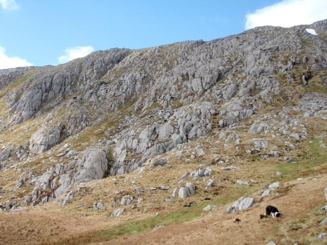
The plateau above the engines, with the crash site central just below the skyline

The plateau above the engines, with the crash site central just below the skyline

'Mist' on the plateau next to part of the aircraft undercarriage

‘Mist’ on the plateau next to part of the aircraft undercarriage

The story of the air-crash and the young men who died there replaced the intended Bwlch Eryl Farchog trip, and the original plan was left for another day. Border Collie ‘Mist’ wasn’t particularly bothered where we went so long as she got a good walk out, and was happy to pose next to bits of wreckage to give an idea of scale.

Looking up to the crash site

Looking up to the crash site

More aircraft wreckage in the gully

More aircraft wreckage in the gully

The account of the crash I had read previously had mentioned that the point of impact had been in a gully heading up to the ridge above. I ignored the advice not to approach the site via the gully itself, on the grounds that I’m a grown-up and experienced enough in the hills to make my own decisions. The gully was steep, but with no technical difficulties, and I passed more aircraft wreckage on the way up.

The top of the second gully, with the last remnants of the winter snow

The top of the second gully, with the last remnants of the winter snow

Above the gully there was a boulder field with no trace of any wreckage, and next to the gully I had ascended there was a second gully with the last remnants of the winter snow. There was little doubt that the aircraft had impacted in one of the gullies, but the small snowfield prevented any further exploration. I spent a few moments thinking about the loss of four young lives, but time was passing and it was soon time to go.

Above the crash site, heading for Carnedd Llewelyn

Above the crash site, heading for Carnedd Llewelyn

.... and soon the mist came down

…. and soon the mist came down

I joined the main path heading towards Carnedd Llewelyn, but the fine weather wasn’t going to hang around any longer and soon the mist came down. From the summit I descended north, heading towards Foel Grach and its small stone refuge (see post #134).

Looking back towards Craig yr Ysfa- the snow patch on the left is the crash site

Looking back towards Craig yr Ysfa- the snow patch on the left is the crash site

Heading southeast from Foel Grach, I descended out of the cloud.  Looking back towards Craig yr Ysfa, it was easy to pick out the crash site by locating the small patch of snow in the gully. From this angle it was apparent that another 30 metres (100ft) of altitude would have saved the aircraft and the airmen on board.

Our way home

Our way home

The small reservoir of Melynllyn

The small reservoir of Melynllyn

Dulyn reservoir

Dulyn reservoir

Looking in the opposite direction towards Conwy on the coast, the weather was starting to improve, with the cloud breaking up. A bit of ‘off-piste’ wandering took me past the two small reservoirs of Melynllyn and Dulyn, to pick up a good track heading back to the car park. Once on the track I made good speed with a good Royal Marine  ‘Yomp’ pace, but the dog clearly wasn’t impressed – Situation normal, as they say!

OLYMPUS DIGITAL CAMERA

Text and images © Paul Shorrock


Filed under: 5. North Wales, Aircrash Sites, Border Collies, General Interest Tagged: Border Collie, Carneddau, hillwalking, mountains, photography, Snowdonia

#156 – Y Garn and Foel Goch in the Glyderau

$
0
0
Foel Goch from the High Level path above Nant Ffrancon

Foel Goch from the High Level path above Nant Ffrancon

Map showing my route, and the site of the aircrash of February 1945

Map showing my route, and the site of the aircrash of February 1945

After my recent Carneddau trip (see post #155) I had checked the map and realised that I had passed close to several aircraft crash sites on the route – most of these date back to WW2, when training flights sometimes ended in tragedy in the mountains of Snowdonia. This time I’d decided on a day out in the Glyderau, mainly to check out a path I had read about running below the slopes of Y Garn and Foel Goch. Whilst checking the route I came across the story of a flying accident in 1945 – a bit of history with the walk seemed like a good idea.

Llyn Idwal with Twll Du (The Devil’s Kitchen) behind

Llyn Idwal with Twll Du (The Devil’s Kitchen) behind

The path from Idwal slabs to Twll Du

The path from Idwal slabs to Twll Du

 The well maintained path below Twll Du

The well maintained path below Twll Du

Looking back towards the lake of Llyn Idwal with Pen yr Ole Wen beyond

Looking back towards the lake of Llyn Idwal with Pen yr Ole Wen beyond

Many a good day out on the hills of the Glyderau starts off from Ogwen Cottage, and this was no exception. I took the east side of Llyn Idwal, passing under the rock climbers’ crag of Idwal Slabs (see post #87) before heading up towards Twll Du (‘The Black Hole’ but usually called ‘The Devil’s Kitchen’ by we English). Although the ascent is fairly steep in places, the constantly changing views made it enjoyable.

Border Collie ‘Mist’ at Llyn y Cwn

Border Collie ‘Mist’ at Llyn y Cwn

First view of Y Garn to the north

First view of Y Garn to the north

At the top of Twll Du I arrived at the small mountain lake of Llyn y Cwn (The Dogs Lake) but on this occasion I had to make do with just one dog, my constant hill-buddy, Border Collie ‘Mist’ – the great thing about walking in the hills with a dog is that they never complain, never ask for the map and never get bored posing for the camera.  Keep an eye on your lunch though!

Looking back to Tryfan (left) and Bristly Ridge (centre skyline) on Glyder Fach

Looking back to Tryfan (left) and Bristly Ridge (centre skyline) on Glyder Fach

View of Crib Goch (left skyline) and Cwm Glas (just below centre skyline)

View of Crib Goch (left skyline) and Cwm Glas (just below centre skyline)

From the lake I had a good view of Y Garn (‘The Cairn’) to the north and equally good views of old friends Tryfan with nearby Bristly Ridge and a more distant view across to Cwm Glas near Yr Wyddfa (Snowdon) featured here in July (see post #154). Y Garn was the objective for today though, and on the easy walk up towards the summit my thoughts were on the tragic accident that occurred here in February 1945.

* * *

B-26 Martin Marauder

B-26 Martin Marauder

In January 1945, sixteen B-26 Martin ‘Marauder’ Bombers set off on a long flight from Florida to the USAAF base at Burtonwood in the Northwest of England. WW2 was drawing to a close, and there was little danger from enemy aircraft – the main danger was the winter weather in the North Atlantic, and the aircraft were routed via Trinidad, Brazil, Dakar and Marrakech to avoid the storms. Ironically, it was bad weather on the final leg from St Mawgan in Cornwall to Burtonwood that led to the accident on 1st February.

‘Mist’ at the approximate location of the first impact

‘Mist’ at the approximate location of the first impact

Looking towards the top of the cliff where half of the wreckage ended up

Looking towards the top of the cliff where half of the wreckage ended up

Looking down into Cwm Cywion where the remainder of the wreckage fell

Looking down into Cwm Cywion where the remainder of the wreckage fell

Low cloud and bad visibility sowed the seeds for the disaster, added to strong winds that pushed the aircraft off course, and instead of taking up the approach for the airfield at Burtonwood, the aircraft crashed into Y Garn, just to the north of the summit – the aircraft was only 100 kms (62 miles) from its final destination. All five members of the crew were killed instantly, and the aircraft broke in two, with part of the wreckage lying at the top of the cliffs above Cwm Cywion, and the remainder lying in the cwm below.

Another view of the cwm, with Tryfan and the lake of Llyn Ogwen beyond

Another view of the cwm, with Tryfan and the lake of Llyn Ogwen beyond

Y Garn from the north – the stony area above the cliff (right of centre) is the upper wreckage site

Y Garn from the north – the stony area above the cliff (right of centre) is the upper wreckage site

On 2nd February, the aircraft was posted as missing, and at 1445hrs the RAF Mountain Rescue Team at Llandwrog, near Caernarvon, was notified. Information had been received from a bus driver in the Llanberis Pass that a low flying aircraft had been heard in the area on 1st February, followed by the sound of an explosion. The rescue team found the wreckage at 1845hrs on 2nd February, but recovery of the bodies had to be delayed until the next day, due to atrocious weather conditions.

The memorial near Blaen y Nant in the Llanberis Pass

The memorial near Blaen y Nant in the Llanberis Pass

Close up of the memorial

Close up of the memorial

The wreckage above the cliffs remained in place for many years, before being removed in the 1970’s, though some of the remains of the aircraft may still be found at the lower site in Cwm Cywion. In the mid-1980’s, Arthur Evans of the Snowdonia Aviation Historical Society arranged for the placing of a memorial to the lost airmen near Blaen y Nant in the Llanberis Pass.

* * *

The northern cliffs of Foel Goch

The northern cliffs of Foel Goch

Looking northwest towards Elidir Fawr

Looking northwest towards Elidir Fawr

It was time for me to continue the route. The dog and I made good progress heading towards Foel Goch and Elidir Fawr (see post #90). I’d been here a couple of weeks earlier, helping with the marshalling of the Snowdon 7’s Race, where three of us had had a blustery and wet couple of hours on Foel Goch summit, but conditions today were brilliant. Elidir Fawr wasn’t on today’s menu though – I was looking for a path leaving the ridge, heading down to a high level path above the Nant Ffrancon valley.

The start of the descent ….

The start of the descent ….

…. before heading towards the stone wall (dead centre in the photo)

…. before heading towards the stone wall (dead centre in the photo)

The northeast cliffs of Mynydd Perfedd, site of two more air-crash sites

The northeast cliffs of Mynydd Perfedd, site of two more air-crash sites

The start of the high level path back to Ogwen, with Nant Ffrancon below

The start of the high level path back to Ogwen, with Nant Ffrancon below

Sure enough, the path turned up, exactly where it should have been. A short descent led to a right turn and a wander across the upper part of Cwm Bual to a  stone wall that made a great navigational handrail; to the left lay the cliffs of Mynydd Perfedd, where there are two more aircrash sites, one from 1943 and the other 1944, both accidents involving Avro Ansons – a total of nine lives were lost in these two separate flying accidents.

The path just visible left of centre ….

The path just visible left of centre ….

…. going on ….

…. going on ….

…. and on

…. and on

Back at Llyn Idwal, complete with beach

Back at Llyn Idwal, complete with beach

From Cwm Bual the high level path was easy to find and to follow, though lack of wear suggests that not many come this way. In places it was little more than a sheep track, and at times there were some nicely airy views down to Nant Ffrancon below. Before long I had picked up the worn path coming off the Northeast Ridge of Y Garn, leading the dog and I down to the shoreline of Llyn Idwal, where the warm weather had tempted several swimmers into the lake – the dog declined the offer of a swim, but settled for a paddle instead.

On the last leg for home

On the last leg for home

Text and images © Paul Shorrock


Filed under: 5. North Wales, Aircrash Sites, Border Collies Tagged: Border Collie, Cwm Idwal, Glyderau, hillwalking, mountain rescue, mountains, photography, Snowdonia

#158 – Back in the Carneddau

$
0
0
Carnedd Dafydd seen from the north

Carnedd Dafydd seen from the north

The route, including the location of the air-crash site

The route, including the location of the air-crash site

The mountains of the Carneddau in North Wales are a fairly recent obsession for me – when I first walked here, I started by checking out the main summits (as you do) then began exploring odd corners where people tend not to go. But sometimes I feel the need to stride off across the heights, and this was one of those days.

On Mynydd Du, the broad grassy Northwest Ridge of Carnedd Dafydd

On Mynydd Du, the broad grassy Northwest Ridge of Carnedd Dafydd

Looking east towards Yr Elen ….

Looking east towards Yr Elen ….

…. and the view southwest to the mountains of the Glyderau

…. and the view southwest to the mountains of the Glyderau

Looking down the steep slopes to the river below (Afon Llafar) ….

Looking down the steep slopes to the river below (Afon Llafar) ….

…. and the view back down the ridge

…. and the view back down the ridge

The Carneddau are not glamourous, exciting hills like the Snowdon Range or Glyderau, but they have their moments. The mountains may lack the sharp, knife-edge ridges of the other ranges, but they are huge in area, and these mountains make up the largest land mass higher than 750 metres (about 2500ft) south of the Scottish border. A walk here is usually going to be a ‘biggy’!

Border Collie ‘Mist’ above the Afon Llafar

Border Collie ‘Mist’ above the Afon Llafar

One last look back along the route of ascent from the summit of Carnedd Dafydd ….

One last look back along the route of ascent from the summit of Carnedd Dafydd ….

…. and a totally different view looking in the opposite direction towards the Glyderau

…. and a totally different view looking in the opposite direction towards the Glyderau

The next objective – Carnedd Llewelyn

The next objective – Carnedd Llewelyn

Side view of the route up Carnedd Dafydd looking west

Side view of the route up Carnedd Dafydd looking west

There was a simple plan – start from Gerlan near Bethesda, and head for Carnedd Dafydd via the broad grassy Northeast Ridge, a route I hadn’t taken before. A dull day with ‘flat’ light conditions didn’t hold much hope for photographs, but things improved along the way. The map suggested that the long ridge would be a bit of a plod, but the ascent passed quickly. My next objective was Dafydd’s big brother, Carnedd Llewellyn, but I had a small diversion along the way.

* * *

Avro Lincoln bomber

Avro Lincoln bomber

Most of the military air-crash sites in the hills of the UK date back to WW2, when flying training was carried out more frequently and often in poor weather conditions, but some accidents occurred in peacetime. On the night of 14th March 1950 an Avro Lincoln bomber took off from RAF Scampton on a training flight, but weather conditions deteriorated during the flight, and Avro Lincoln RF511 was one of three aircraft diverted to RAF Valley on Anglesey.

The crash site, just below Bwlch Cyfryw Drum, with Carnedd Dafydd behind

The crash site, just below Bwlch Cyfryw Drum, with Carnedd Dafydd behind

The view down to where the remains of the aircraft lie

The view down to where the remains of the aircraft lie

The other two aircraft landed safely at 0300hrs on 15th March, but at about the same time news came in from Bethesda police station that an aircraft had crashed nearby. Half an hour later the RAF Mountain Rescue team based at Valley set out to the crash site, arriving there at 0520hrs. The crew of six were all killed in the crash – a Court of Inquiry determined that the likely cause was that the aircraft had turned onto a South-easterly course over Anglesey instead of the reciprocal course out to sea.

Just above the crash site looking southwest

Just above the crash site looking southwest

The same aspect from the slopes of Carnedd Llewelyn, with the impact site dead centre

The same aspect from the slopes of Carnedd Llewelyn, with the impact site dead centre

There is very little evidence of the crash at the impact site, but larger pieces of wreckage still lie in the cwm below.

* * *

Different terrain of the return leg

Different terrain of the return leg

The east face of Yr Elen, seen on the descent from Carnedd Llewelyn ….

The east face of Yr Elen, seen on the descent from Carnedd Llewelyn ….

…. and more Carneddau ponies

…. and more Carneddau ponies

After my visit to the crash-site, I carried on over Carnedd Llewelyn, the highest peak in the range – from there it wasn’t quite ‘all down hill’, but the hard work was done. On the way, my attention was drawn to the east face of Yr Elen, where the Northeast Ridge was looking good in the afternoon light, and I found myself already planning my next day out in the hills.

The high path back to Bethesda

The high path back to Bethesda

The strange rocks making up the summit of Yr Aryg ….

The strange rocks making up the summit of Yr Aryg ….

…. and further on, Bera Bach

…. and further on, Bera Bach

However, I still had this walk to finish. After Llewelyn came Foel Grach, Carnedd Gwenllian (formerly named Garnedd Uchaf), followed by Yr Aryg, Bera Bach and Gyrn Wigau.  The descent is over rolling grassy hills, rather than the mountain ridges on the ascent, but it made for fast easy walking.

Heading for the last summit of the day ….

Heading for the last summit of the day ….

…. Gyrn Wigau

…. Gyrn Wigau

Bethesda in the distance

Bethesda in the distance

Last view of Carnedd Dafydd – the route of ascent in this post is just right of centre

Last view of Carnedd Dafydd – the route of ascent in this post is just right of centre

 I later realised why Border Collie ‘Mist’ seemed to be in such a hurry – dinner time takes priority over everything!

“Get a move on – it’s dinner time!”

“Get a move on – it’s dinner time!”

Text and images © Paul Shorrock


Filed under: 5. North Wales, Aircrash Sites, Border Collies Tagged: Border Collie, Carneddau, hillwalking, mountains, photography, Snowdonia

#159 – Horses and Dragons – The Northeast Ridge of Yr Elen

$
0
0
Yr Elen

Yr Elen

The route (clockwise) with Yr Elen, the aircrash site (1) and the site of the wreckage (2)

The route (clockwise) with Yr Elen, the aircrash site (1) and the site of the wreckage (2)

One of the highlights of my trip out the previous week (see post #158) had been a great view of Yr Elen in the afternoon light. Yr Elen looks like a ‘proper’ mountain, but doesn’t get too many visitors as it lies at the end of a spur, isolated from the main plateau. The light had picked out the Northeast Ridge, known as the ‘Dragon’s Teeth Ridge’, and before I got back to the car I had decided that this would be my next trip out.

The northwest side of Yr Elen just after setting out – not looking promising ….

The northwest side of Yr Elen just after setting out – not looking promising ….

…. but sunshine over the hills of the Glyderau!

…. but sunshine over the hills of the Glyderau!

Yr Elen stands at a height of 962 metres (3156 feet) making it one of the 15 mountains in Wales over 3000 feet high. I had decided to follow the river (Afon Caseg) to what is regarded as the most remote cwm (valley) in Wales. At the head of the valley lies a small lake called Ffynnon Caseg (the ‘Mare Spring’) named after the wild ponies frequently seen in these hills.

Old sheepfold by Afon Caseg, with my valley route stretching out ahead

Old sheepfold by Afon Caseg, with my valley route stretching out ahead

Remains of the ancient settlement, with Yr Elen beyond

Remains of the ancient settlement, with Yr Elen beyond

View of the Glyderau from the ancient settlement

View of the Glyderau from the ancient settlement

The weather didn’t exactly look promising as I set off, but the cloud started to lift as I passed an ancient settlement, possibly dating back to the Bronze Age – the stones used to build the settlement were later plundered in the 18th Century to build a nearby sheep fold. The Bronze Age builders certainly had a good eye for a view, with the nearby hills of the Glyderau dominating.

My route, heading towards where the valley narrows

My route, heading towards where the valley narrows

Waterfall in the upper reaches of the narrowed valley ….

Waterfall in the upper reaches of the narrowed valley ….

 …. and the view looking back to the route in

…. and the view looking back to the route in

The walk in to the settlement had been fairly level, but as the valley ahead narrowed the faint track started to gain height.

Cwm Caseg, possibly the most remote cwm in Wales, with the small lake of Ffynnon Caseg

Cwm Caseg, possibly the most remote cwm in Wales, with the small lake of Ffynnon Caseg

Looking up to the summit of Yr Elen, with the Northeast Ridge on the right skyline

Looking up to the summit of Yr Elen, with the Northeast Ridge on the right skyline

Border Collie ‘Mist’ at the ruins of the old hafod

Border Collie ‘Mist’ at the ruins of the old hafod

The ruins of the hafod, thought to have once been the highest in Wales, next to the small lake

The ruins of the hafod, thought to have once been the highest in Wales, next to the small lake

The cwm comes as a complete surprise, with a tiny lake sitting below towering crags. Next to the lake lie the ruins of a tiny hafod (summer dwelling) thought to have been the highest in Wales when it was occupied. The long walk in, and the remote setting, must have made this a very lonely place to live, and getting the groceries delivered must have been a headache to say the least!

View down to the hafod (just visible) and the lake seen from the Dragon’s Teeth Ridge

View down to the hafod (just visible) and the lake seen from the Dragon’s Teeth Ridge

“Here be Dragons …” – the ‘Dragon’s Teeth Ridge’ alias the Northeast Ridge

“Here be Dragons …” – the ‘Dragon’s Teeth Ridge’ alias the Northeast Ridge

Looking down to my walk-in route ….

Looking down to my walk-in route ….

…. and looking up to more ‘Dragons Teeth’

…. and looking up to more ‘Dragons Teeth’

‘Mist’ chilled out, and unimpressed by all the talk about dragons

‘Mist’ chilled out, and unimpressed by all the talk about dragons

The view back down the ridge

The view back down the ridge

“Come on then – we haven’t got all day!”

“Come on then – we haven’t got all day!”

There were no horses at the ‘Mares Spring’ today, so it was time to check out the Northeast Ridge for Dragon’s Teeth. The ridge is well named, as the rocky crest is decorated with sharp rocky teeth, making for spectacular views, though there is no technical difficulty – I kept a fairly steady pace going up, with an impatient Border Collie checking back to see why I was taking so long.

The northeast facing cliffs of Yr Elen, leading to Carnedd Llewelyn ….

The northeast facing cliffs of Yr Elen, leading to Carnedd Llewelyn ….

…. and a view of the previous week’s route up Carnedd Dafydd (see post #158)

…. and a view of the previous week’s route up Carnedd Dafydd (see post #158)

Carnedd Llewelyn ahead ….

Carnedd Llewelyn ahead ….

…. but we’re going ‘off-piste’ (the Lincoln crash site is the rocks central in the photo)

…. but we’re going ‘off-piste’ (the Lincoln crash site is the rocks central in the photo)

An attractive ridge joins Yr Elen to Carnedd Llewelyn, the highest peak in the Carneddau group at 1064 metres (3490 feet), but this wasn’t on today’s tick list – instead I went ‘off-piste’, heading for the site of the aircrash that occurred here on 15 March 1950, and which I had visited the previous week (see post #158)

Small shelter at the wreckage site utilising part of the seat armour from the aircraft

Small shelter at the wreckage site utilising part of the seat armour from the aircraft

Looking uphill to the impact site, roughly in the centre of the photo

Looking uphill to the impact site, roughly in the centre of the photo

Memorial plaque to the crew members killed in the crash

Memorial plaque to the crew members killed in the crash

Part of the aircraft undercarriage

Part of the aircraft undercarriage

 Rusty propeller hub and the view down the valley towards Bethesda

Rusty propeller hub and the view down the valley towards Bethesda

Aluminium spar from the aircraft

Aluminium spar from the aircraft

Avro Lincoln RF 501 was a peacetime aircrash, unusual in an area where most of the aircraft crashes occurred in WW2. The previous week I had found few signs of the accident at the impact site, high above the cwm, but lower down there were still large items of identifiable wreckage. The memorial plaque tells its own sad story, with two of the aircrew having been decorated for bravery in the war – the pilot, Squadron Leader John Shore, had been captured after being shot down on a bombing raid, and had subsequently escaped and made his way back to England.

My route out down Nant Fach ('Small Stream')

My route out down Nant Fach (‘Small Stream’)

The cliffs of Ysgolion Duon (The ‘Black Ladders’) on Carnedd Dafydd

The cliffs of Ysgolion Duon (The ‘Black Ladders’) on Carnedd Dafydd

Looking back towards the head of the valley (crash site to the left and Ysgolion Duon right)

Looking back towards the head of the valley (crash site to the left and Ysgolion Duon right)

My route back to the car took me below the impressive cliffs of Ysgolion Duon (the ‘Black Ladders’). The afternoon sun made the crags look quite inviting, but there is nothing for the summer rock climber here as the cliff is best known for its collection of fierce winter climbs. Having had two good Carneddau days in as many weeks, a plan began to hatch as I walked out. I had a route in-waiting crossing the Carneddau plateau, that I had been putting off for some time – another week of fine weather would remove the excuses ….

Heading home

Heading home

Text and images © Paul Shorrock

p.s. the weather did hold out, and a week later I was out again on a crossing of the Carneddau Plateau from Ogwen to Conwy – almost 30 kms (18 miles) with 1521 metres (5000 feet) of height gain. Come back in two weeks for the story in post #160


Filed under: 5. North Wales, Aircrash Sites, Border Collies Tagged: Carneddau, hillwalking, mountains, photography, Snowdonia, Yr Elen

#162 – The Berwyns? Where’s that? – Part 1

$
0
0
The Berwyn Ridge from Llyn Lluncaws

The Berwyn Ridge from Llyn Lluncaws

The mountains of the Berwyns are best summarised as “The mountains the planners forgot”.  Standing between Llangollen, Corwen, Bala and Oswestry they are a significant bit of upland, but someone in an office decided that the Rhinogs, Arenigs, and Aran Ridge should be included in the Snowdonia National Park, but the Berwyns should not, despite the fact that one of the Seven Wonders of Wales, the waterfall at Pistyll Rhaeadr (see post #85) is one of the attractions.

The hills of the Berwyn range (route marked by the dots in the centre)

The hills of the Berwyn range (route marked by the dots in the centre)

Closer view of the route

Closer view of the route

Setting off from near Pistyll Rhaeadr

Setting off from near Pistyll Rhaeadr

Mind you, it has to be said that they are rough, wild hills. In 1165, Henry II of England decided that an invasion of Gwynedd was a good idea, and decided to take a route over the Berwyns as a surprise for the Welsh princes – it was Henry who got the surprise though, and after several days of heavy rain over hills covered in thigh-deep heather, the English army turned round and squelched their way back to Oswestry.

The Berwyn Ridge comes into view with Moel Sych (left) and Cadair Berwyn (right)

The Berwyn Ridge comes into view with Moel Sych (left) and Cadair Berwyn (right)

Approaching the lake – Llyn Lluncaws

Approaching the lake – Llyn Lluncaws

The view back to the valley ….

The view back to the valley ….

 …. and the start of the climb up to Moel Sych

…. and the start of the climb up to Moel Sych

I had already had my Berwyn initiation – when I joined my local mountain rescue team NEWSAR (North East Wales Search And Rescue) I had to pass a navigation assessment to go on the callout list. Fellow trainee Richie Boardwell and I had an evening ‘bushwhacking’ through the high heather that characterises these hills, but I found myself wanting to go back and see more. The late fine spell in September gave the opportunity to explore, so Chris and I decided on the classic approach to the Berwyn Ridge from the waterfall at Pistyll Rhaeadr.

Still with some way to go – and a drop to one side!

Still with some way to go – and a drop to one side!

How to deal with a drop? Move away from it!

How to deal with a drop? Move away from it!

The route follows a good track from the waterfall, heading for the Berwyn ridge stretching from Moel Sych to Cadair Berwyn. The track leads to the lake at Lynn Lluncaws before turning left towards the main ridge. I was enjoying the view down the steep drop to the lake when I realised that Chris was most definitely not enjoying the view down the steep drop! A slight adjustment of our course kept everyone happy.

Heading towards the ‘un-named top’

Heading towards the ‘un-named top’

The Fiona McWilliam memorial

The Fiona McWilliam memorial

We passed Moel Sych and headed for the ‘un-named top of Cadair Berwyn – for many years walkers must have thought it strange that an un-named intermediate summit seemed higher than the adjacent peaks of Moel Sych and Cadair Berwyn. The answer was that the usually accurate national survey had got it wrong! On the way to the summit we passed the memorial to Fiona McWilliam, who died in a flying accident here in 1999 – the Cessna light aircraft in which she was a passenger was apparently caught in a downdraft, crashing just below the ridge. No signs of the sad accident remain, apart from the memorial itself.

The last few metres to the highest point

The last few metres to the highest point

The author looking pleased with himself for some reason!

The author looking pleased with himself for some reason!

Heading for Cadair Berwyn, with the stone shelter on the right

Heading for Cadair Berwyn, with the stone shelter on the right

The stone shelter near the un-named top

The stone shelter near the un-named top

The un-named top from the shelter

The un-named top from the shelter

The true summit lies between Moel Sych and the trig point on Cadair Berwyn, and is not named on the Ordnance Survey map. For years it was assumed that Moel Sych and the trig point were joint high points at 827 metres (2713 feet) each, before it was discovered that a tiny ring contour at 830 metres (2723 feet) had been overlooked. The ‘new’ summit certainly looks and feels more like a mountain top than the other two.

Cadair Berwyn ahead

Cadair Berwyn ahead

Looking back along the Berwyn Ridge from Cadair Berwyn

Looking back along the Berwyn Ridge from Cadair Berwyn

Heading back to the col and the memorial

Heading back to the col and the memorial

Llyn Lluncaws below, with the outward route beyond

Llyn Lluncaws below, with the outward route beyond

We didn’t linger, and after checking out the stone shelter near the top we carried on to the trig point on Cadair Berwyn. From there it was a simple case of retracing the route along the Berwyn Ridge to Moel Sych and then following the fence line down to our start point in the valley. What could possibly go wrong …. ?

The way we should not have gone ….

The way we should not have gone ….

…. and looking back at the way we should have taken!

…. and looking back at the way we should have taken!

It’s been a long time since I made a navigational error. When teaching navigation skills I always point out the dangers of making a mistake by being distracted, which is exactly what happened in this case. The turn to the valley was obvious enough, but Chris and I were chattering away about something and we walked past the turn. Fortunately the route must have been running in the back of my mind, and after about 500 metres I had the feeling that things didn’t look right!

On our way back to the valley ….

On our way back to the valley ….

A quick map check confirmed the error, and we avoided a return to the summit of Moel Sych by contouring round the slopes. Back on course it was a steady descent back to the waterfall, but as usual I was already plotting the next trip out. On the map, the two broad ridges to the east of the Berwyn Ridge appeared to give a good ‘horseshoe’ walk, and the views from the top had confirmed that. The only question was, would the fine weather hold out?

…. and the final descent

…. and the final descent

p.s. The fine weather did hold out – read about it in two weeks’ time.

Text and images © Paul Shorrock


Filed under: 5. North Wales, Aircrash Sites, General Interest Tagged: Border Collie, hillwalking, mountains, photography, Snowdonia

#163 – The Berwyns? Where’s that? – Part 2

$
0
0
The Berwyn Ridge from Mynydd Tawr

The Berwyn Ridge from Mynydd Tawr

Overview map of routes in posts #162 and #163

Overview map of routes in posts #162 and #163

Route from post #162 in blue and #163 in red

Route from post #162 in blue and #163 in red

A walk in an area that I’m not too familiar with usually prompts a return visit, and the Berwyn Ridge (see post #162) was no exception, so in less than a week I was back again and enjoying the fine settled spell of weather we had for much of October. It looked like being a bit of a leg stretcher though, so Chris opted out of this one leaving Border Collie ‘Mist as my companion for the day.

The return leg – Godor (centre) seen from Mynydd Tawr

The return leg – Godor (centre) seen from Mynydd Tawr

A long, steady ascent to start with ….

A long, steady ascent to start with ….

…. then a long rolling ridge ….

…. then a long rolling ridge ….

…. and a view of the Berwyn Ridge ahead

…. and a view of the Berwyn Ridge ahead

The plan was to follow the ridge line over Mynydd Tarw, Foel Wen and Tomle to join the Berwyn Ridge, then crossing Cadair Berwyn before dropping down onto Moel yr Ewig to return via Godor – in effect doing a horseshoe route of Cwm Maen Gwynedd. After a short ascent of Mynydd Tarw, the way ahead was a long roller-coaster ride, with great views towards the Berwyn Ridge.

The route ahead ….

The route ahead ….

…. and looking back at the route behind

…. and looking back at the route behind

Cadair Berwyn (in the centre)

Cadair Berwyn (in the centre)

The final section of ascent to the Berwyn Ridge

The final section of ascent to the Berwyn Ridge

‘Mist’ at the boundary stone at the bwlch

‘Mist’ at the boundary stone at the bwlch

The Berwyns have a reputation for rough heathery ground, but the route was easy going in this case. From Tomle I passed a boundry stone at a bwlch (Welsh for ‘pass’) before the final height gain to the Berwyn Ridge – the high ground ahead was the setting for a double tragedy in 1942, with two flying accidents occurring within a day of each other.

* * *

Supermarine Spitfire

Supermarine Spitfire

Westland Lysander

Westland Lysander

‘Mist’ at the site where the Spitfire came to rest

‘Mist’ at the site where the Spitfire came to rest

On 14th December 1942, Sergeant Pierre Degail of the Free French Air Force set out from RAF Mountford Bridge on a training flight in a Spitfire. The weather was good, but something caused the aircraft to crash on Cadair Berwyn. The next day, Flight Lieutenant Douglas Harvey Walker left the same airfield flying a Lysander spotter aircraft. He was tasked with searching for the missing Spitfire, and despite poor weather conditions he was successful in locating the crash.

The view that Sgt Degail would have had from the wreck

The view that Sgt Degail would have had from the wreck

The cwm where the Lysander crashed

The cwm where the Lysander crashed

As he circled the wrecked Spitfire, which was mainly intact, he saw that Sgt Degail was still alive and in the cockpit of the aircraft.  Moments later the Lysander was caught in a downdraught, and crashed in the adjacent cwm, within 300 metres of the Spitfire.   Flt/Lt Walker was killed in the crash, and when a rescue party reached the Spitfire they discovered that Sgt Degail had died of exposure – his legs had been broken in the crash, and he would have been unable to find shelter from the freezing weather conditions.

Boeing B-17 Flying Fortress

Boeing B-17 Flying Fortress

The Flying Fortress crashed into the hillside to the right of the trees below the crag

The Flying Fortress crashed into the hillside to the right of the trees below the crag

How much sadness can one small bit of Welsh hillside hold? On 11th August 1942, just four months earlier, an American B17 Flying Fortress on a training flight had crashed into the hillside immediately below the final resting place of the Spitfire, in a completely unrelated accident – the crew of 11 were all killed.  (On checking the map when I got home, I realised that I had passed within 500 metres of yet another air crash site – on 23rd March 1940 a Bristol Blenheim crashed on the slopes of Mynydd Tarw whilst also on a training flight)

* * *

Looking back to my outward route from the Spitfire crash site

Looking back to my outward route from the Spitfire crash site

Continuing towards Cadair Berwyn

Continuing towards Cadair Berwyn

Craig Berwyn and daredevil sheep

Craig Berwyn and daredevil sheep

The only other human I saw all day – just below Cadair Berwyn

The only other human I saw all day – just below Cadair Berwyn

The view down to Llyn Lluncaws

The view down to Llyn Lluncaws

I left the scene of the double tragedy behind me, and carried on over Cadair Berwyn – these hills are remarkably quiet, and apart from some daredevil sheep who had found a good source of grass on the rocks of Craig Berwyn, the only other life on the summit ridge was one lone walker, the only other human I saw all day.

The start of the descent to Moel yr Ewig

The start of the descent to Moel yr Ewig

Further down the path ….

Further down the path ….

…. and looking back to the descent

…. and looking back to the descent

The return ridge

The return ridge

Final view of the Berwyn Ridge

Final view of the Berwyn Ridge

Then it was time to head back along the other broad ridge. A steep descent took me down to Moel yr Ewig, before a ‘yomp’ across a moor that was almost Pennine in character. The final view of the Berwyn Ridge from Godor soon dispelled that idea though – these are real mountains, without any doubt!

Heading down to the valley

Heading down to the valley

Text and images © Paul Shorrock


Filed under: 5. North Wales, Aircrash Sites, General Interest Tagged: Berwyns, Border Collie, hillwalking, mountains, photography, Snowdonia

#169 – Brecon Beacons day – Craig Fan Du, Corn Du, Pen y Fan and Cribyn

$
0
0
Brecon Beacons skyline – Pen y Fan is the highest peak towards the left

Brecon Beacons skyline – Pen y Fan is the highest peak towards the left

Looking towards Cribyn (centre) and Pen y Fan (left of centre)

Looking towards Cribyn (centre) and Pen y Fan (left of centre)

The route (clockwise)

The route (clockwise)

Living on the edge of the Clwydian Hills, with Snowdonia just an hour away by car, it’s easy to ignore the other hills and mountains of Wales. Last summer we took a trip south including a couple of days out in the hills, and our attention turned towards the Brecon Beacons. I’ve written about the Beacons before (see post #38) and we haven’t had a bad day here yet – Pen y Fan (the highest peak in the Beacons) was on the menu again, but this time from a different direction.

The lane towards the Neuadd Reservoirs

The lane towards the Neuadd Reservoirs

Looking down towards the Neuadd Reservoirs

Looking down towards the Neuadd Reservoirs

Our trips to Mid and South Wales usually include a visit to friends, and Barbara was up for a walk in the Beacons as part of her preparation for a trekking trip in the Himalayas. The horseshoe circuit from the Neuadd Reservoirs looked good on the map, and included the summits of Graig Fan Ddu, Corn Du, Pen y Fan and Cribyn. With a good weather forecast thrown in, we had all the ingredients to make a good day out.

The final steep bit up an unpleasant earthy gully ….

The final steep bit up an unpleasant earthy gully ….

…. before reaching a level path ….

…. before reaching a level path ….

…. heading towards Craig Fan Ddu

…. heading towards Craig Fan Ddu

An easy walk up a lane loosened us up for the major height gain of the day – 200 metres over a distance of 800 metres was always going to feel a bit steep, but it didn’t take long to reach the top of the 25% slope. An unpleasantly loose earthy gully brought us to almost level ground at Craig Fan Ddu – whilst Chris and Barbara took the easy path, I went off-piste with Border Collie ‘Mist’ to visit the scene of a tragic WW2 flying accident.

* * *

Supermarine Spitfire

Supermarine Spitfire

In May 1942, Spitfire X4588 of 53 Operational Training Unit RAF Llandow, piloted by Sergeant Donald Perry Carruthers of the Royal Canadian Air Force, took off to take part in a formation flying exercise. A combination of bad weather and a small error in navigation resulted in the aircraft becoming detached from the formation. The aircraft subsequently crashed on the summit of Graig Fan Ddu, killing Sgt Carruthers.

Memorial cairn at the crash site

Memorial cairn at the crash site

The site is now marked by a small cairn incorporating some of the wreckage from the aircraft, and a glint of metal helped me home in. Some people find these sites macabre whilst others find them ugly – for me they are a fitting memorial to the sacrifices made by others to preserve the freedoms we often take for granted. I stayed in silence for a couple of minutes before sending ‘Mist’ off to find Chris and Barbara– in a short time she was back with me, barking to indicate where the others were.

* * *

Heading towards the ridge of Rhiw yr Ysgyfarnog

Heading towards the ridge of Rhiw yr Ysgyfarnog

‘One man and his dog’ – Pen y Fan (centre) and Corn Du (left)

‘One man and his dog’ – Pen y Fan (centre) and Corn Du (left)

Still on the level path ….

Still on the level path ….

…. heading to Rhiw yr Ysgyfarnog

…. heading to Rhiw yr Ysgyfarnog

Cwm Crew dropping down to the south-west

Cwm Crew dropping down to the south-west

“Looks like another dog to me” – ‘Mist’ spots another Border Collie ahead

“Looks like another dog to me” – ‘Mist’ spots another Border Collie ahead

Having made our major height gain for the day, the route now was a steady wander towards Corn Du and Pen y Fan. The broad ridge narrowed at Rhiw yr Ysgyfarnog, but not enough to bother Chris who isn’t too keen on big drops. The main interest for the humans was the unmistakable skyline ahead, but ‘Mist’ was far more interested in another Border Collie heading towards us!

Craig Fan Ddu now well behind us ….

Craig Fan Ddu now well behind us ….

…. with Corn Du and Pen y Fan ahead ….

…. with Corn Du and Pen y Fan ahead ….

…. and Cribyn and Pen y Big on the opposite side of the Valley

…. and Cribyn and Pen y Big on the opposite side of the Valley

Looking back at the pass of Bwlch Duwynt we had great views of Craig Fan Ddu, now well behind us. Corn Du and Pen y Fan were directly ahead, and across the valley our last summit, Cribyn, was waiting.

Corn Du with Pen y Fan beyond

Corn Du with Pen y Fan beyond

Looking back towards Corn Du on the way to Pen y Fan

Looking back towards Corn Du on the way to Pen y Fan

Pen y Fan summit with the ITERA race paying a visit

Pen y Fan summit with the ITERA race paying a visit

A small height gain took us to the top of Corn Du, quickly followed by the main attraction of Pen y Fan. The summit was busy with competitors on the ITERA race, a 5 day nonstop adventure race for mixed gender teams of 4. The route is about 600 kms in length, and includes running, trekking, mountain biking, kayaking, canyoneering and some rope work. It made our day out look quite puny in comparison!

Start of the descent from Pen y Fan with Cribyn ahead

Start of the descent from Pen y Fan with Cribyn ahead

The route up Cribyn

The route up Cribyn

Heading back towards the Neuadd Reservoirs

Heading back towards the Neuadd Reservoirs

Upper Neuadd Reservoir (centre)

Upper Neuadd Reservoir (centre)

The descent down Craig Cwm Sere is rough and steep, which aggravated an already ‘grumbling’ knee joint with Chris. At the start of the ascent of Cribyn, she decided to take the easier path contouring round the south-west side. I went with her to keep her company, but Barbara was in turbo mode now – she went solo for Cribyn, and soon caught us up at Bwlch ar y Fan. From there it was downhill, passing the Neuadd Reservoirs on the other side.    The next day the rain was torrential!

Heading for home with Cribyn (centre) and Pen y Fan/Corn Du (beyond and left)

Heading for home with Cribyn (centre) and Pen y Fan/Corn Du (beyond and left)

Text and images © Paul Shorrock


Filed under: 6. Mid and South Wales, Aircrash Sites, Border Collies Tagged: Border Collie, Brecon Beacons, hillwalking, mountains, photography

#170 – The Cambrian Mountains of Mid-Wales

$
0
0
Looking east from Pumlumon Fawr towards Pumlumon Llygad Bychan

Looking east from Pumlumon Fawr towards Pumlumon Llygad Bychan

The route

The route

Although many in the UK will remember the late summer of 2014 that lasted from September until the end of November, it’s easy to forget that August was well rainy, and Chris and I spent a soggy few days in Mid-Wales dodging the showers. One of the walking targets for the trip was a corner of the Cambrian Mountains near Aberystwyth called Pumlumon (it’s pronounced ‘Pimlimon’ and means ‘Five Peaks’) but our first attempt was abandoned due to the rain.

Setting out near Eisteddfa Gurig

Setting out near Eisteddfa Gurig

The track opening out by the Afon Tarennig

The track opening out by the Afon Tarennig

Above the old mine workings, heading for Pen Pumlumon Fawr

Above the old mine workings, heading for Pen Pumlumon Fawr

Bad weather doesn’t last forever, even if it sometimes feels that way, so after an escape to the rain free Brecon Beacons (see post #169) we tried again for Pumlumon. The route starts out from the busy A44 road at Eisteddfa Gurig, and initially takes a much older road to old lead mine workings.

Heading ‘off-piste’

Heading ‘off-piste’

The view to the south

The view to the south

At the lead mine it was time to take to a hill track, which heads straight for the top of Pumlumon Fawr – we didn’t follow it for long though, as one of the objectives of the trip was to visit the site of a WW2 air-crash. A short section ‘off-piste’ led us across the bare hillside, and before long we could pick out the unmistakable sight of weathered aluminium.

* * *

Lockheed P38 Lightning/F-5E

Lockheed P38 Lightning/F-5E

On 11 September 1945, a Lockheed F-5E of the 27nd Photographic Reconnaissance Unit USAAF was being ferried from Chalgrove in Oxfordshire to Burtonwood near Warrington. The Lockheed F-5E was a variant of the better known P38 Lightning, and was identical apart from the addition of four cameras in the nose of the aircraft. During the flight, the aircraft struck a ridge with a glancing blow losing its propellers, then continued for some distance before inverting and crashing into the hillside. The pilot, Lt Xenophon Eugenedes, was killed in the crash.

The crash site

The crash site

Still some large sections remaining

Still some large sections remaining

The wreckage was seen the following day by a shepherd, and the location reported to the police. Investigators concluded that the pilot lost control while flying on instruments in cloud, and was recovering from a dive when the aircraft struck the ground. It has been speculated that had the aircraft been flying ten feet higher, the crash would not have occurred.

* * *

Old boundary stone just a little higher than the crash site

Old boundary stone just a little higher than the crash site

Looking west towards Pen Pumlumon Fawr (752 metres)

Looking west towards Pen Pumlumon Fawr (752 metres)

Approaching the summit on Pen Pumlumon Fawr

Approaching the summit on Pen Pumlumon Fawr

Our route continued to take in a couple of the Pumlumon summits starting with Pumlumon Llygad Bychan. A slight descent was then followed by a steady and gradual climb to the highest summit of the range, Pumlumon Fawr at 752 metres (2467ft).

‘Mist’ at the summit with Nant y Moch Reservoir below

‘Mist’ at the summit with Nant y Moch Reservoir below

Remains of the Bronze Age cairn at the summit

Remains of the Bronze Age cairn at the summit

Time to head back

Time to head back

As with many of the summits of Welsh mountains, the top was crowned with an ancient Bronze Age burial cairn, probably 4-5000 years old – another common feature of such summits is that the stones of the cairn are often ransacked to build wind shelters, and this was no exception, though I suppose we might have been more grateful had the weather been bad…

Heading south from the cairn

Heading south from the cairn

The two small pools on Pen y Drawsallt ahead

The two small pools on Pen y Drawsallt ahead

Losing height at last

Losing height at last

Heading back was downhill all the way – the rough hillside became a grassy path that morphed into a forestry track. We just ‘dipped our toes in the water’ on this trip, but we will probably return to dip our toes for real – these hills are the sources of three important rivers, the Afon Rheidol, the Afon Gwy (River Wye) and the Afon Hafren (River Severn, the longest river in Britain), but the stories of the rivers will have to wait for another day.

The track home by the forest

The track home by the forest

Text and images © Paul Shorrock


Filed under: 6. Mid and South Wales, Aircrash Sites Tagged: Border Collie, hillwalking, mountains, photography

#171 – Visiting the neighbours – Ogwen Valley Mountain Rescue Organisation

$
0
0
Cwm Lloer below Pen yr Ole Wen and Carnedd Dafydd in the mountains of the Carneddau

Cwm Lloer below Pen yr Ole Wen and Carnedd Dafydd in the mountains of the Carneddau

Each spring, my mountain rescue team (North East Wales Search And Rescue) go on-call for an evening and night looking after our neighbouring area, while the resident team (Ogwen Valley Mountain Rescue Organisation) have their annual dinner dance – it’s a good arrangement and Oggie team return the favour by looking after our ‘patch’ when NEWSAR have their Christmas ‘do’.

‘Oggie Base’ – Ogwen Valley Mountain Rescue Organisation

‘Oggie Base’ – Ogwen Valley Mountain Rescue Organisation

It’s also a great opportunity to go over to visit Oggie Base, and several NEWSAR members are to be found there during the day, either depleting Oggie’s tea and coffee stocks or going off into the mountains of the Ogwen Valley. There’s a limit to how much caffeine I can get through in a day, so I had brought boots and rucksack along for the trip.

Start of the walk up to Cwm Lloer

Start of the walk up to Cwm Lloer

The view towards Pen yr Ole Wen in Cwm Lloer

The view towards Pen yr Ole Wen in Cwm Lloer

Looking southeast across the lake of Ffynnon Lloer

Looking southeast across the lake of Ffynnon Lloer

None of my hill days would be complete without Border Collie ‘Mist’, and she soon became restless sitting around Oggie Base being fussed – a walk was clearly indicated, but the weather forecast was dire!   Winds of 50-60 mph were predicted, with gusts over 70 mph – I love the mountains of the Carneddau, but making progress high up in those conditions was not going to be fun. In the end I decided on a more sheltered trip into Cwm Lloer to visit some air-crash sites.

* * *

Cessna 310

Cessna 310

The wreck site of Cessna 310F G-ARMK

The wreck site of Cessna 310F G-ARMK

On 29 September 1968, a Cessna 370 aircraft left Leavesden in Hertfordshire to fly to Blackpool. The pilot was flying on instruments due to bad weather conditions, but for some reason the aircraft deviated from the planned route and flew into the mountain of Carnedd Dafydd, killing the pilot.

Looking up towards Pen yr Ole Wen (left)

Looking up towards Pen yr Ole Wen (left)

Modern wrecks are usually cleared within a matter of days, as was the Cessna site. There was allegedly an engine block still at the site, but the book recording air accidents in the hills of the UK only gives 6-figure map references, which are only accurate to 100 metres. I didn’t waste too much time looking for a lump of steel whilst gale-force winds pushed me round the hillside, and I turned instead towards the slopes of Pen yr Ole Wen.

Lockheed Ventura

Lockheed Ventura

Impact point of the Ventura, in the centre below the ridge

Impact point of the Ventura, in the centre below the ridge

The Ventura impact point was above this cliff

The Ventura impact point was above this cliff

On the 18th August 1943 a Lockheed Ventura of 464 Squadron of the Royal Australian Air Force flew from RAF Sculthorpe on a night navigation exercise. The aircraft crashed into Carnedd Dafydd at 2238hrs – the weather was recorded as being fine and the reasons for the crash are not clear. The crew of four all died in the crash – unusually for an Australian aircraft, three of the crew were Canadian.

Avro Anson

Avro Anson

The impact point of the Anson was in the centre of the photo

The impact point of the Anson was in the centre of the photo

Three months later, on the evening of the 8 November 1943, an Avro Anson took off from RAF Halfpenny Green in Staffordshire for a night navigation exercise passing over Rhyl, Conwy, the Isle of Man and Bridgenorth before returning to Base. The aircraft was plotted at one point by the Royal Observer Corps on a route that appeared to be a direct track from Wrexham to Conwy. This should not have taken the aircraft into the mountains, but on the night there was a 15 mph wind blowing from the northwest which caused the aircraft to drift south. At around 2030hrs the aircraft crashed into the slopes of Pen yr Ole Wen, killing the crew of five which included one Australian, one Canadian and three Britons.

Looking down to the lake of Ffynnon Lloer

Looking down to the lake of Ffynnon Lloer

The view across Ffynnon Lloer towards Capel Curig

The view across Ffynnon Lloer towards Capel Curig

Aircraft wreckage (just beyond 'Mist' in the centre)

Aircraft wreckage (just beyond ‘Mist’ in the centre)

The two accidents were in no way connected, though the impact points were only 550 metres apart. Because Cwm Lloer is a bowl shape, gravity took over and the two wrecks tumbled down the hillside to come to rest in exactly the same location, near to the lake of Ffynnon Lloer. There is little to see now, as souvenir hunters have removed much of what remained.

‘Mist’ next to an aluminium panel from one of the aircraft

‘Mist’ next to an aluminium panel from one of the aircraft

It was time to head back to Oggie Base.  Myself and four other NEWSAR members were staying there overnight, looking forward to a quiet night of telling jokes and tall tales. In the Ogwen Valley the night drew in and the laybys and parking areas emptied.    Except for one car ….

* * *

Whilst we were finishing our chicken curry and pizza, a group of three young men were struggling to escape the gale force winds on the Carneddau Plateau. They had set off from Abergwyngregyn (Aber) that morning, intending to cross the plateau from north to south heading for their car at Ogwen. (I did a slightly longer route the other way round in September 2014 – see post #160). As the wind was from the southwest, they would have been sheltered from the worst of the weather until they gained the plateau.

The route taken by the group (intended route in blue, escape route in red, abandoned routes dotted)

The route taken by the group (intended route in blue, escape route in red, abandoned routes dotted)

The map shows the intended route in blue, with dashes showing the route actually covered. Somewhere between Foel Grach and Carnedd Llewelyn they decided to ‘bail out’ to escape the wind. Their escape route into Cwm Eigiau (shown in red) was sensible and safe, though it added another 10kms to a route that was already 20kms in length. By 2000hrs they had run out of light and then run out of steam – they took shelter near the dam at Llyn Cowlyd and phoned for help.

The dam at Llyn Cowlyd

The dam at Llyn Cowlyd

Back at Oggie Base, we left the washing up for later. It was a long drive round from Ogwen to Llyn Cowlyd, but a narrow road up from Trefriw and a good track meant that we could drive most of the way to the group – a short walk out soon had them in the Landrover. Back at Oggie base they told us their story – their navigation had been accurate, and the escape route they decided on was safe in every respect, though a little on the long side.

The intended escape route alongside Llyn Cowlyd and below Creigiau Gleision

The intended escape route alongside Llyn Cowlyd and below Creigiau Gleision

The only error they made was failing to realise how difficult it is to walk into 60 mph winds, but that only comes with experience and let’s face it you only get experience by having experiences!   The group got themselves warmed up before being dropped off at their car, while we settled down again at Oggie Base to continue our attack on the stock of coffee.

Looking up to the Carneddau Plateau from the Ogwen Valley, Pen yr Ole Wen on the left

Looking up to the Carneddau Plateau from the Ogwen Valley, Pen yr Ole Wen on the left

Text and images © Paul Shorrock

p.s.   Some people find the remains of the aircraft crashes macabre, others find them untidy.   For me they are part of the history of our mountains, in the same way as the stone circles, abandoned settlements, disused quarries and similar relics. If visiting crash-sites, please show respect and care – some wrecks occasionally have live ammunition nearby, and a small number of sites are classed as War Graves due to the difficulty of finding all human remains.


Filed under: 5. North Wales, Aircrash Sites, General Interest, Mountain Safety Tagged: Border Collie, Carneddau, hillwalking, mountain rescue, mountaineering, mountains, photography, Snowdonia

#182 – Coniston Old Man and Swirl How

$
0
0
Between Coniston Old Man and Swirl How

Between Coniston Old Man and Swirl How

The route

The route

I’ve been writing routes for Walking World for several years now, and one of my earliest contributions was Coniston Old Man and Swirl How, returning by the Coppermines Valley.    Not only is it one of my earliest routes for them, it’s also a consistently good seller.    However, things change, even on the hills, so when I was looking for a Lakes route for Chris and buddies Richie and Babs Boardwell I jumped at the chance to repeat this trip.

Setting out from the Walna Scar Road

Setting out from the Walna Scar Road

The old mine workings

The old mine workings

Above Low Water

Above Low Water

Richie, Babs and Chris approaching the summit of Old Man, Coniston Water behind

Richie, Babs and Chris approaching the summit of Old Man, Coniston Water behind

The author and Border Collie ‘Mist’ at the summit

The author and Border Collie ‘Mist’ at the summit

There are several good ways to the summit of Coniston Old Man, but for my money the route through the old mine workings has the most interest, and the last time that Chris and I had visited the Old Man (see post #179) we had come up this way.    It’s also the most popular (and easiest) way to the top, and is guaranteed to be busy, but once past the summit things quieten down a bit.

Leaving the summit of Coniston Old Man

Leaving the summit of Coniston Old Man

Heading north for Swirl How

Heading north for Swirl How

Babs getting down to serious photography

Babs getting down to serious photography

Start of the descent to Levers Hawse ….

Start of the descent to Levers Hawse ….

…. and up the other side towards Great How ….

…. and up the other side towards Great How ….

…. with Seathwaite Tarn in the background

…. with Seathwaite Tarn in the background

From Coniston Old Man the route is a broad, easy-walking ridge.    It wasn’t quite as quiet as anticipated as there was a mountain marathon on at the time (can’t remember what event it was), and we were passed by some very earnest looking fell-runners with that far-away look of pain and anticipation that goes with the game.    Along the way, Babs went about increasing her portfolio of ‘Dogs and Landscapes’ images – for Babs there’s only one way to get a good dog photo, and that’s to get down with the doggies!

 Little How and Great How

Little How and Great How

Swirl How ahead

Swirl How ahead

Looking back towards Great How ….

Looking back towards Great How ….

…. with Coniston Old Man (left) and Dow Crag (centre)

…. with Coniston Old Man (left) and Dow Crag (centre)

The final bit of ascent to Swirl How

The final bit of ascent to Swirl How

The route takes a couple of small ups and downs before ending up right on the summit of Swirl How.    The summit of Great Carrs was just a short distance away, with a memorial to the crew of a wartime aircrash – on 22nd October 1944 a Halifax bomber on a navigation exercise struck the hillside, killing the crew of eight.    Unfortunately the day was getting on and we didn’t have time to make the diversion to visit the site.

The descent ridge of Prison Band on the skyline (seen from Levers Water)

The descent ridge of Prison Band on the skyline (seen from Levers Water)

Heading down to Levers Water from Swirl Hawse

Heading down to Levers Water from Swirl Hawse

Collie collection!

Collie collection!

Levers Water ahead

Levers Water ahead

Near Levers Water ….

Near Levers Water ….

…. with Swirl How in the background

…. with Swirl How in the background

It was time to head back – the route down the East Ridge of Swirl How goes by the ominous name of Prison Band, but although the ground is broken and rocky it isn’t a serious obstacle.   We passed Levers Water before heading down to the Coppermines Valley to finish, trying to ignore the happy group at one of the holiday lets who had decided it was ‘Wine O’Clock’ – it only made our experience sweeter when we opened our own bar a short time afterwards.

Final bit of ‘bracken bashing’

Final bit of ‘bracken bashing’

Heading for home – Coppermines Valley

Heading for home – Coppermines Valley

Text and images © Paul Shorrock


Filed under: 2. Lake District, Aircrash Sites, Border Collies Tagged: Border Collie, Cumbria, hillwalking, Lake District, mountains, photography

#197 – Winter wanderings in the Carneddau

$
0
0
Winter in the Carneddau

Winter in the Carneddau

Winter in the mountains usually means playtime in the snow, but this year the snow in North Wales has been infrequent and transitory, so when the weather settled down and the gales stopped blowing, it was time to get out in the white stuff.    No better place to start than the East side of the mountains of the Carneddau.

Setting out – the snow looking a bit sparse ….

Setting out – the snow looking a bit sparse ….

…. and the ground looking a bit soggy!

…. and the ground looking a bit soggy!

Our plan was to have a walk out to the bothy at Dulyn beneath Foel Grach, then to continue to the lakes of Dulyn (Black Lake) and Melynllyn (Yellow Lake).    From our start point at the car park for Cwm Eigiau at 375 metres altitude it looked as though playtime in the snow wasn’t about to start anytime soon, and it became apparent that a thaw had set in.    It looked like a soggy day lay ahead.

A bit more snowy at 450 metres

A bit more snowy at 450 metres

Local residents – Carneddau ponies managing to find some grazing

Local residents – Carneddau ponies managing to find some grazing

Blue sky behind ….

Blue sky behind ….

…. but a bit bleak ahead

…. but a bit bleak ahead

Small stand of trees, just visible in the distance in the previous photo

Small stand of trees, just visible in the distance in the previous photo

At 450 metres we finally hit the snow line – it was surprising that the wild Carneddau ponies hadn’t headed for lower ground, but they seemed to be finding enough grazing.  Perhaps they had that sixth sense telling them that snow in March isn’t going to hang around long, and the blue sky we left behind us indicated more fine weather to come.  Ahead though, it looked as though the Carneddau was still locked in winter.

At last, Dulyn bothy standing at 500 metres

At last, Dulyn bothy standing at 500 metres

Dulyn bothy

Dulyn bothy

Chris just can’t resist a bit of tidying up!

Chris just can’t resist a bit of tidying up!

A room with a view

A room with a view

One man and his dog – the author at Dulyn bothy

One man and his dog – the author at Dulyn bothy

Dulyn is one of just a handful of bothies in North Wales.    This abandoned shepherds hut has been taken over by the Mountain Bothies Association with the owner’s permission, and is available for use by all as a shelter and stopover in this remote corner of the mountains.  The facilities are rudimentary to say the least, but the room and walls are sound and there is a stove for those prepared to carry in the fuel – what it lacks in facilities is more than made up for in location!

Leaving the bothy and heading for the lake ….

Leaving the bothy and heading for the lake ….

…. about 300 metres away and 25 metres higher

…. about 300 metres away and 25 metres higher

300 metres beyond the bothy is the lake of Dulyn – in the almost monochrome conditions it certainly lived up to the name ‘Black Lake’ today!    In November 1944 the crag above the lake was the scene of a tragic accident, when a USAAF Douglas C-47 ‘Skytrain’ (Dakota) transport aircraft crashed into the cliff.    The aircraft was flying from Le Bourget in France to Warrington in the north of England when it was diverted to RAF Valley on Anglesey due to bad weather.

Douglas C-47 'Skytrain' (Dakota)

Douglas C-47 ‘Skytrain’ (Dakota)

The lake at Dulyn – the Dakota crash site is approximately in the centre of the crag

The lake at Dulyn – the Dakota crash site is approximately in the centre of the crag

The aircraft crashed in low cloud, but it was eleven days before a RAF radio maintenance party on Foel Grach saw the wreck – the crew of four had all died in the accident.    Some of the wreckage of the aircraft remained on the cliff until the late 1940’s, but divers found more wreckage in the lake in 1972.    When the water level is low, a propeller assembly can still be seen near the stream flowing out from the lake.

Leaving Dulyn and heading up to Melynllyn

Leaving Dulyn and heading up to Melynllyn

Melynllyn – the 'Yellow Lake'

Melynllyn – the ‘Yellow Lake’

Border Collie ‘Mist’ finds a spot for a lie down ….

Border Collie ‘Mist’ finds a spot for a lie down ….

…. but a dog biscuit is more tempting!

…. but a dog biscuit is more tempting!

There was a cold wind blowing, even though we were only at 525 metres, so we soon pressed on to the second lake which is at 640 metres – the height gain soon had the blood flowing!    ‘Mist’ decided to ‘chill out’ by scraping a den under a convenient boulder, but the prospect of a dog biscuit by the lake soon became much more interesting.

By the shore of Melynllyn

By the shore of Melynllyn

Time to head for home

Time to head for home

Then it was time to head back – the snow was knee deep in places, with the surface variable, sometimes bearing weight and sometimes not.    As the route had been my idea I did the decent thing by breaking trail for Chris, and when we reached the Melynllyn track we soon shifted up a gear.    It was so good that I was back the next day with skis

Back again the day after, with skis this time – on the track to Melynllyn

Back again the day after, with skis this time – on the track to Melynllyn

I have a set of Salomon x-adv69  cross-country skis that I had been dying to try out all winter, and the track out to Melynllyn was just the place  – unfortunately the thaw had advanced overnight, but I managed a short trip out on them.  Best of all (in the circumstances) they weigh less than 2 kilos, so carrying up to the snow line was fairly painless – roll on next winter!

Heading home, the outbound ski tracks just visible

Heading home, the outbound ski tracks just visible

Text and images © Paul Shorrock


Filed under: 5. North Wales, Aircrash Sites, Border Collies Tagged: Border Collie, Carneddau, hillwalking, mountains, photography, snow, Snowdonia

#212 – Bleaklow from Snake Pass

$
0
0
The Pennine Way near Bleaklow

The Pennine Way near Bleaklow

I’m not saying that I’ve turned into a ‘fair weather walker’, but It’s good to be able to pick and choose hill days according to the conditions.    It doesn’t always work that way though – I had to taxi Chris to an event in Stockport and was looking for a short-ish day out for me and Border Collie ‘Mist’.    The Pennine Way National Trail passes nearby, crossing the A57 Snake Pass road, so that was an easy decision – the harder decision was whether I should bother on a damp misty afternoon.

Setting out from Snake Pass, with Higher Shelf Stones in the distance

Setting out from Snake Pass, with Higher Shelf Stones in the distance

The Snake Pass gets its name, not from the winding nature of the road (or even the presence of snakes!) but from the Snake Inn on the east side of the high point of the road.    The road was completed by Thomas Telford in 1821 as the Glossop to Sheffield Turnpike, and with a high point of 512 metres it was the highest turnpike road in the country – the Romans were here first though, and built their slightly higher road about 1,500 years earlier.

The Pennine Way starts off as a well-made path ….

The Pennine Way starts off as a well-made path ….

…. but slowly starts to merge in with the moors

…. but slowly starts to merge in with the moors

The one thing that both Telford and the Romans would have recognised would have been the bleak weather, and the nearby summit plateau of Bleaklow is well named.    On my visit the mist was swirling round Higher Shelf Stones, which was exactly where I was heading.    I took the Pennine Way heading north, which starts out as a well-made path, but it isn’t long before the moor starts to take charge.

Looking east, down to Hern Clough, the visibility not too bad ….

Looking east, down to Hern Clough, the visibility not too bad ….

…. but me and Border Collie 'Mist' are heading west towards Higher Shelf Stones!

…. but me and Border Collie ‘Mist’ are heading west towards Higher Shelf Stones!

The moor becomes more Pennine in character

The moor becomes more Pennine in character

First signs of the crash site

First signs of the crash site

Before long it was time to leave the Pennine Way trail to head off into the mist.   This wasn’t just an aimless wander though, I was on a mini-pilgrimage to visit the site of a modern tragedy.    On the 3rd November 1948, a Boeing B-29 Superfortress bomber of the United States Air Force was on a routine flight from RAF Scampton in Lincolnshire to the US base at Burtonwood near Warrington – the aircraft never reached its destination.

*    *    *    *    *

B-29 Superfortress

B-29 Superfortress

B-29 Superfortress, "Overexposed"

B-29 Superfortress, “Overexposed”

The Crash site

The Crash site

 The B-29 Superfortress was one of the largest aircraft used during WW2 – it was certainly the most sophisticated.    It was designed as a high-altitude bomber, with a pressurised cabin and remote control gun turrets, able to fly higher than the enemy fighters of the time.     The type only saw service in the far east against Japan, but after the war the B-29 stayed in use until the advent of the modern jet fighter made it obsolete.

One task at which the B-29 excelled was photo-reconnaissance, and the B-29 involved in the Bleaklow accident was one of these variants.     Nicknamed “Overexposed”, the aircraft had flown photographic missions in 1946 at the atomic weapons tests at Bikini Atoll, and afterwards flew in Europe during the Berlin Airlift in 1948.

On the day of the accident, “Overexposed” was on a routine ‘milk-run’ to collect mail and pay from Burtonwood.     Scampton was a much smaller airbase, lacking the comforts that US aircrews took for granted, so instead of just the basic crew needed to fly the aircraft the whole crew turned out for some serious R&R and leisure time at Burtonwood.

It isn’t certain what happened to cause the aircraft to crash on a routine 30-minute flight, but it is known that the high ground was hidden by low cloud.     The Captain would have been aware of this, and should have maintained height longer – instead it appears that he commenced his descent to Burtonwood on the planned schedule, but a strong headwind meant that the B-29 had not cleared the high ground.

“Overexposed” struck the ground at an altitude of 612 metres; nearby Higher Shelf Stones was the highest ground on the planned route at 621 metres altitude.     Had the B-29 had been a mere 10 metres (33 ft) higher the accident may never have happened.     First on the scene was the RAF Mountain Rescue Team from Harpur Hill – team members had been training on the moors nearby and secured the scene before the recovery of the victims the next day.

The US officer in charge of the operation had requested (more like demanded) that helicopters be provided to assist the operation, but these were still few in number and had a low payload.     The officer then demanded (more like insisted) that a road be built to the site – anyone who knows the Pennine moors will appreciate how impossible a task this would have been.     In the end, it was the RAF team who set off across the moor with general-issue folding stretchers.

A contemporary account makes harrowing reading – it was obvious from the injuries sustained that all the crew had died instantly.    In the event, the stretchers were not needed as the Americans provided body bags, making the recovery operation much easier.  No one knew about PTSD in those days, so the RAF lads simply ‘got on with the job’ – it is recorded though that they were very grateful for the containers of hot stew provided by the Americans, a rare treat as food rationing was still in force in the UK

The memorial plaque © Geotek

The memorial plaque © Geotek

© Anthony Parkes

© Anthony Parkes


The memorial

The memorial

*    *    *    *    *

The Trig Point at Higher Shelf Stones (621 metres)

The Trig Point at Higher Shelf Stones (621 metres)

Border Collie “Mist” at Hern Stones

Border Collie “Mist” at Hern Stones

The site had a melancholy feel on my visit, though a dank mist did nothing to lighten the mood.    Some argue that the aircraft wrecks are unsightly or even gruesome, and should be cleared from the mountains and moors, but I disagree – they are part of the history of these lands, in the same way that the old abandoned mines and quarries are, and in some cases the sites are classed as war graves.

Near Hern Stones, the Pennine Way follows the stream leading to Hern Clough

Near Hern Stones, the Pennine Way follows the stream leading to Hern Clough

The Wain Stones

The Wain Stones

The weather wasn’t getting any better, and I had to complete my duties as taxi driver, so a brief visit to the trig point at Higher Shelf Stones was followed by an even shorter visit to Hern Stones and the famous Wain Stones (see post #19).     Then it was a quick yomp back down the Pennine Way to the Snake Pass road, leaving the moors to the ghosts of the past.

Back on the Pennine Way, heading for home

Back on the Pennine Way, heading for home

Text and images © Paul Shorrock except where indicated – these images are reproduced under a Creative Commons Licence

p.s.  unknown to me at the time, my mates Richie and Babs Boardwell were just a bit further down the Snake Pass, having their own Peak District day – a pity I didn’t know, as Babs is a much better photographer than I am!


Filed under: 4. Northern England, Aircrash Sites Tagged: Border Collie, hillwalking, mountain rescue, Peak District, Pennine Way

#217 – The Carneddau and Llyn Llyffant

$
0
0
The remote lake of Llyn Llyffant, the highest lake in Wales (820 metres above sea level)

The remote lake of Llyn Llyffant, the highest lake in Wales (820 metres above sea level)

Since moving to North Wales five years ago, I’ve become a big fan of the mountains of the Carneddau, and I’m still having fun exploring hidden corners where I haven’t been yet.   One place on my ‘to do’ list for some time was the highest lake in Wales – sitting at 820 metres (2690 ft) above sea level, Llyn Llyffant (‘Frog Lake’) is also one of the smallest lakes in Wales.    A trip there was long overdue, so last July I set out for a visit.

The route, clockwise from the car park

The route, clockwise from the car park

The Carneddau

The Carneddau

Setting out towards Cwm Eigiau

Setting out towards Cwm Eigiau

Cwm Eigiau and the crags of Craig yr Ysfa

Cwm Eigiau and the crags of Craig yr Ysfa

The tiny lake is located just below Carnedd Llewelyn, the highest peak of the Carneddau, but the most logical way in seemed to be via one of my favourite Carneddau spots, Cwm Eigiau.    The views on the walk-in are constantly changing, with the highlight being the magnificent climbers’ crag of Craig yr Ysfa.

Craig yr Ysfa

Craig yr Ysfa

Legend has it that the crag was spotted by telescope in the late 19th Century by one of the famous rock-climbing Abraham Brothers – this would have quite a feat, as the telescope and user were in the Lake District at the time, about 150 kms away (90 miles or so), but there is a clear line of sight from Scafell Pike to Craig yr Ysfa, so the story may well be true.

Small waterfall on the Afon Eigiau

Small waterfall on the Afon Eigiau

The upper reaches of the Afon Eigiau, not far from its source

The upper reaches of the Afon Eigiau, not far from its source

From the Cwm I followed the small Afon Eigiau stream up to the lake.    The area is hardly ever visited, being off the beaten track, but in December 1957 it suddenly became the focus of much attention following a tragic aircraft crash.

*     *    *    *    *

English Electric Canberra

English Electric Canberra

The English Electric Canberra came into service with the Royal Air Force in 1951 as the first British jet-powered bomber, and for the rest of the decade the Canberra could fly higher than any other aircraft in the world, holding the world altitude record of 70,310 ft (21,430 metres).   Designed originally as an unarmed, high-altitude bomber the type became a versatile workhorse in service in the UK and beyond.

The initial impact point of the Canberra on Carnedd Llewelyn (Photo Sept 2014)

The initial impact point of the Canberra on Carnedd Llewelyn (Photo Sept 2014)

On 9th December 1957 Canberra WK129 was taking part in secret radar tests.    The aircraft had flown from RAF Pershore in Worcestershire to the Carneddau, where it carried out trials with a radar station on the summit of Drum (traces of the radar station can still be found there).    The Canberra continued out to Puffin Island near Anglesey before turning to travel back to base.

Aircraft wreckage in the Afon Eigiau

Aircraft wreckage in the Afon Eigiau

Looking up towards the lake of Llyn Llyffant

Looking up towards the lake of Llyn Llyffant

The aircraft was flying in patchy low cloud when it struck Carnedd Llewelyn on the ridge connecting the mountain to Foel Grach.   The forward end of the aircraft broke up,  leaving fragments of the forward fuselage on western side of the ridge. The centre section, wings and rear fuselage crashed to earth near Llyn Llyffant, though other pieces did travel some distance beyond here.    The destruction of the aircraft was such that the crew of two must have died instantly.

More wreckage from the Canberra

More wreckage from the Canberra

The reason for the crash remains a mystery, though the aircraft was below its safety height at the time of the accident.    A possible explanation is engine failure due to icing – icing conditions on the day of the flight were forecast above 3000 ft, and the initial impact point is at around 3280 ft (1000 metres)

*     *    *    *    *

Border Collie ‘Mist’ at Llyn Llyffant

Border Collie ‘Mist’ at Llyn Llyffant

Llyn Llyffant is now remote and quiet and would make a great wild camp site.    I stopped for a coffee and sandwich break, ably assisted (with the sandwiches anyway) by Border Collie ‘Mist’.

Next to the lake

Next to the lake

Looking back towards Llyn Llyffant

Looking back towards Llyn Llyffant

Left to right - Pen Llithrig y Wrach, Pen yr Helgi Du and Craig yr Ysfa

Left to right – Pen Llithrig y Wrach, Pen yr Helgi Du and Craig yr Ysfa

Small group of Carneddau ponies and the only humans I saw all day

Small group of Carneddau ponies and the only humans I saw all day

When it came time to leave I set off for another air-crash site nearby.  Although overcast, the visibility was great with great views back to the mountains surrounding upper Cwm Eigiau (Pen Llithrig y Wrach, Pen yr Helgi Du and Craig yr Ysfa) and despite the fair conditions, I saw just four other humans all day.

The crash site of Avro Anson EG110

The crash site of Avro Anson EG110

On 14th January 1943, an Avro Anson on a training flight struck the side of Foel Grach.  There are several Anson crash-sites near to here, not because the Anson was an unsafe aircraft, but because there were many more flights over this part of Wales in WW2.    The crew survived the impact, and the pilot managed to walk to a farm in the valley below.    The RAF Mountain Rescue Team from Llandwrog (now Caernarfon Airport) set out and searched into the night, but had to take shelter in deteriorating weather.   The aircraft was found the next day with one survivor, the other two crew members having died of exposure.    There is now no trace of the crash.

‘Mist’ with Melynllyn (reservoir) below

‘Mist’ with Melynllyn (reservoir) below

Heading back along the ridge of Cefn Tal Llyn Eigiau

Heading back along the ridge of Cefn Tal Llyn Eigiau

The mountains of the UK are steeped in history, and the air-crash sites I had visited are part of that ongoing story, and make a fitting memorial to those who died, but I now had another important task lined up – ‘Mist’ was just about overdue for her dinner time, so it was time to head back home.

Back on the track – time to head for home

Back on the track – time to head for home

Text and images © Paul Shorrock


Filed under: 5. North Wales, Aircrash Sites, Border Collies Tagged: Border Collie, Carneddau, hillwalking, mountain rescue, mountains, photography, Snowdonia

#218 – Dulyn and Melynllyn in winter and summer (From the archives)

$
0
0
Early March 2016 – snow on the Carneddau, on the way out to Dulyn

Early March 2016 – snow on the Carneddau, on the way out to Dulyn

Winter this year in North Wales has been fairly mild, with high winds and rain but less snow than usual.    Most people would find that good news, but outdoors types aren’t ‘most people’, and my ice axe and crampons haven’t been getting much use lately.    There’s still time though – the above photo was taken on an outing in March 2016, and the day after that I was out on skis in the same area.

Return trip in July 2016 (look closely and Border Collie 'Mist' is in the same place in both shots!)

Return trip in July 2016 (look closely and Border Collie ‘Mist’ is in the same place in both shots!)

On that outing in March 2016, Chris and I, plus Border Collie ‘Mist’, had taken a route out to the bothy at Dulyn in the mountains of the Carneddau (see post #197), the first time that Chris had been out this way.    Four months later (July 2016) it was T-shirt weather in the mountains, and a great opportunity for Chris to see what had been underneath all that white stuff.

Setting out from the car parking area at Cwm Eigiau

Setting out from the car parking area at Cwm Eigiau

Big open spaces ….

Big open spaces ….

…. and wide panoramas

…. and wide panoramas

Dulyn Bothy comes into view

Dulyn Bothy comes into view

For those not familiar with the Carneddau, it’s a lovely semi-wilderness in the mountains of North Wales.    There are traces of human activity, but the big open spaces and wide panoramas can hide most of the mess that we humans inflict on the landscape.  For mountain enthusiasts, one of the more welcome human intrusions in this landscape is the remote bothy near the lake of Dulyn.

The author and 'Mist' at the bothy in July 2016 ….

The author and ‘Mist’ at the bothy in July 2016 ….

…. but a bit colder four months earlier

…. but a bit colder four months earlier

The lake at Dulyn in winter ….

The lake at Dulyn in winter ….

…. and summer (Note the aircraft propeller in the front centre)

…. and summer (Note the aircraft propeller in the front centre)

Although I’ve visited the location several times, I’ve still not spent a night at the bothy, something I must try to rectify this year, though I’ll probably aim for a summer trip to save carrying in wood and coal for the stove.    Slightly higher than the bothy is the small lake of Dulyn, which had looked bleak and gloomy in winter – the July photo shows a warmer scene in every sense.  (The propeller assembly is from a wartime air-crash whose story I told in post #197)

Some of the remains of the old quarry workings

Some of the remains of the old quarry workings

Heading up towards Melynllyn (the path can be made out just right of centre)

Heading up towards Melynllyn (the path can be made out just right of centre)

Border Collie ‘Mist’ herding the humans along ….

Border Collie ‘Mist’ herding the humans along ….

…. but for Chris, it seems there’s a lot of uphill ….

…. but for Chris, it seems there’s a lot of uphill ….

…. just as there had been a lot of uphill four months earlier

…. just as there had been a lot of uphill four months earlier

Nearly at the high point, with Dulyn behind

Nearly at the high point, with Dulyn behind

Looking back down the valley we walked to the Dulyn Bothy

Looking back down the valley we walked to the Dulyn Bothy

From Dulyn it was time for a bit of height gain, starting by old quarry workings near the lake.    We headed up towards the higher lake of Melynllyn, assisted by ‘Mist’ who, coming from a line of good herding dogs, likes to make sure that the humans stay on the right track.   It was warmer work on the July walk than it had been in March, but the height gain was just as steep – it’s fairly short though, and we were soon at the second lake.

Melynllyn in summer ….

Melynllyn in summer ….

…. and in winter

…. and in winter

The route out, with the track just visible in the distance

The route out, with the track just visible in the distance

Melynllyn is another beautiful spot, and it’s sometimes easy to forget that both Dulyn and Melynllyn are reservoirs – the two lakes have blended in to the surrounding countryside so well that they seem to have been there for ever.   In this case, humans may well have made a positive impact on the scenery for once.

Time to head for home ….

Time to head for home ….

…. with Cwm Eigiau coming into view

…. with Cwm Eigiau coming into view

Text and images © Paul Shorrock

p.s.   Winter 2017 has been such a washout (literally) up to now that quality mountain days worthy of a blog post have been few and far between – hopefully, this trip back to the archives will fill the gap for now!


Filed under: 5. North Wales, Aircrash Sites, Border Collies Tagged: Border Collie, Carneddau, hillwalking, mountaineering, mountains, photography, Snowdonia, winter

#219 – Llyn Anafon and Drum in the Northern Carneddau

$
0
0

Looking down towards Llyn Anafon from the slopes of Drum

The route – Anti-clockwise to Llyn Anafon then on to Drum

The Northern Hills of the Carneddau

Although I’m usually up for a long mountain day, me missus enjoys her days in the hills when she isn’t being scared out of her wits or setting off on a long ‘yomp’ into the backwoods in crappy weather.   So, that’s a nice easy brief then!

Setting out up the track above Afon Anafon

The early weeks of 2017 had the usual storms in from the sea, with high winds and loads of rain rather than snow, so a calm day with a sprinkling of snow on the tops was enough reason to get out.  In fact, it would have been hard to come up with an excuse not to, so with all the boxes ticked, a trip to the hills of the Northern Carneddau was in order.

Looking back towards Abergwyngregyn and the coast

Old sheep folds below the track

The last time Chris and I (plus Border Collie ‘Mist’ of course!) came up this way was late autumn 2014 (see post #167).   There is a good track heading up from the road-head beyond the village of Abergwyngregyn on the coast and this gives quick and easy access to a lovely hidden corner of the Carneddau.

Still heading up the track ….

…. with lots of water in the stream below

Drum comes into view ahead

It’s about 4.3 Kms from the carpark to the shoreline of Llyn Anafon with a height gain of about 330 metres, so it’s hardly what you would regard as extreme.   The track follows the stream of the Afon Anafon in a deep valley, with the views beyond restricted, so it was some time before our objective, the 770 metres (2525 ft) summit of Drum, came into view.

The ‘picnic site’ and the view across the lake of Llyn Anafon ….

…. with the picnic on the go ….

…. including the favourite mug!

We weren’t in a rush and we can please ourselves nowadays as to how the day goes, so when we got to Llyn Anafon it was picnic time.   Out came the trusty ‘Jetboil’ stove and instead of an indifferent cup of coffee from a flask we had a fresh brew.   There might even have been a small nip of spiced rum (‘Sailor Jerry’ if you must know) from a different sort of flask, but as I said, we can please ourselves nowadays.

Leaving Llyn Anafon behind and heading up into the snow


The view across to Llwytmor

Having had a bit of a dawdle up from the car park, it was now time to put some effort in (Not TOO much, though – did I mention that we can please ourselves nowadays?)   We had a total height gain of almost 250 metres over 1.25 kms in front of us, which works out (roughly) as a 1-in-5 (20%) slope.

Things start to get steeper ….

…. but as usual, Border Collie ‘Mist’ is ahead and waiting

Things get steeper towards the top though, and there was a height gain of about 150 metres over the last 440 metres of distance, which comes out at about a 1-in-3 (33%) slope.  Added to that was an accumulation of soft, wet snow, so there much slithering about on the steeper stuff – things remained good humoured, but I’m sure I caught the dog laughing at us!

On the bwlch (col) at last – Foel Fras behind

The ancient cairn on the summit of Drum

From the bwlch (col) above the slope, it was an easy stroll to the summit of Drum.   I had intended to get some pics of the what remains of the site of the radar station that had been located here in the mid 1950’s, and which I mentioned in post #217, but all was covered in snow.

*    *    *    *    *

An AEC Matador truck hauling the radar cabins up the narrow lane from Abergwyngregyn

The system was code-named ‘Blue Joker’ and was designed to test radar signal processing from as high a point as was reasonably practical, in order to minimise sea wave interference.  The setup included two mobile cabins, of which one was a modified ‘Type 4 Mk 7 Mobile Radar Unit’ to house the equipment and the other a domestic unit for use by the staff.  In addition, there was a large diesel electric generator.

The convoy at the start of the mountain track

The Royal Electrical and Mechanical Engineers (REME) built the access road from Aber to the site assisted by local council employees, and contemporary photos show that the stone walls alongside the road near to the village were comprehensively trashed!  A heavy ‘AEC Matador’ truck was used to haul the radar cabin, with the domestic unit sitting on the back of an American ‘Diamond T’ tank transporter tractor unit.

'Diamond T' truck carrying the domestic unit and towing the Matador and one of the radar cabins

‘Diamond T’ truck carrying the domestic unit and towing the Matador and one of the radar cabins

It was during the radar trials that the ‘Canberra’ bomber was lost in December 1957 (post # 217).  Although the trials were a success, the Blue Joker project was wound up in the mid-1960’s when the perceived threat changed from manned Soviet bombers to Intercontinental Ballistic Missiles, which this type of radar could not track.

The mobile radar site at the summit of Drum

All that remains now is an area of hardcore that looks immediately out of place at an altitude of 750 metres on a Welsh mountain top – a bit more careful searching will reveal a couple of concrete blocks and a few heavy-duty steel stakes used to anchor the equipment down in the high winds – they had a lot of those!

*    *    *    *    *

The way down ….

…. with the track well ‘snowed in’

One legacy of the huge amount of work that was put in to build the access road is a good track down from the summit of Drum, which since then must have been trod by thousands of weary walkers heading down from the Carneddau – being easy and downhill, it may even have saved a few lives over the years, though the upper part was completely snowed in for our descent.   We still made good speed though – we had a hungry Border Collie to feed!

A last view of Llyn Anafon from the track heading down

As often happens on a day out in the mountains, I was already plotting the next trip out, but I wasn’t expecting to be back out here three days later on a very different mountain day – you can read about it here in a couple of weeks.

Time to head for home

Text and images © Paul Shorrock with the exception of the ‘Blue Joker’ images.

p.s. The ‘Blue Joker’ pics are especially for fellow blogger Mountain Coward, who may know much more about the radar equipment shown from her days in the Army, though the setup in the photos was probably well obsolete before her time.


Filed under: 5. North Wales, Aircrash Sites, General Interest Tagged: Border Collie, Carneddau, hillwalking, mountains, photography, snow, Snowdonia, winter

#220 – Foel Fras – Things don’t go as planned!

$
0
0

The summit of Foel Fras looking north

As Chris and I finished our bimble around Llyn Anafon and Drum (see post #219) we were followed most of the way back by big glowering clouds, and it started to pour down just as we arrived back at the car.   Looking back towards the Carneddau on the drive home, it seemed that Mr Snow had paid a visit to the hills – a return trip three days later seemed like a good idea, but things don’t always go as planned ….

The route – original planned route in red, actual route in blue

The mountains of the Carneddau

The initial plan was simple – I would head up to Aber Falls, take the path to the left of the falls as seen from below, then head up Llwytmor and continue to Foel Fras.   From there I would head south-west to Carnedd Gwenllian then take the path south of Bera Bach and Drosgl before heading back down towards Aber.   A cheeky little 17 kms distance with 1010 metres of height gain was almost Scottish in proportion – six hours was a reasonable estimate.    But, things don’t always go as planned ….

Heading towards Aber Falls ….

…. with much more water than usual!

As we finished our walk three days earlier, it looked as though I could expect a fair amount of snow on high ground on this trip, but the amount of green showing as I set off suggested otherwise.   One thing that soon became apparent, however, was the amount of water in the Afon Rhaeadr Fawr, and as the falls came into view I saw there was much more water than usual.    River crossings were probably off the day’s menu then.

The path to the top of Aber Falls

View of the falls from the path across the scree

I set off on the rising path towards the top of the falls, trailing behind Border Collie ‘Mist’ as usual.   The path crosses a scree slope, before following an entertaining route along rock ledges, followed beyond there by a small rock step.   This requires a bit of care when it wet as it can get greasy, and the ground below drops off towards the waterfall.   Once across the step, the planned route was a long, height-gaining slog up Llwytmor, but things don’t always go as planned ….

Approaching the rock step ….

…. or in this case the greasy, slimy, wet rock step! (Note the drop-off below)

The rock step usually has a damp patch except in a drought, but today it was a small stream!   Wet rock in itself isn’t a problem – the problem here was that three or four metres of ascending rock slab were covered in slime which had the consistency (and friction level) of liquid soap.   I tried the usual crossing point but was forced to retreat.   Other options were tried, including traversing on the grass below the step.  Things were definitely not going as planned.

“Woof! What do you think Boss? Not looking good is it? Woof, Woof!”

A slip or a fall would probably not have been terminal, but one thing was certain – it would hurt, probably a lot!    I’ve been doing this ‘mountain thing’ for most of my life without getting injured, and I wasn’t about to break that record.   Equally, I wasn’t ready to head home.   A change of plan was looking likely.

The solution – planned route in red, actual route in yellow (Photo – October 2014)

Above the screes I had crossed, there was a line of grotty, greasy crags that looked even less appealing than the three or four metres of soapy slab.   The map showed the crags running out as they reached the Coedydd Aber forest.   I didn’t fancy flogging up or across the loose scree, but quite often it’s possible to find solid ground at the foot of crags, so that became the plan.   Sure enough, it was possible to pick a way below the rocks following sheep paths, and I gradually drew nearer to the forest.

At the end of the screes, time to head upwards

Heading towards Llwytmor Bach

Looking towards Bera Mawr and Bera Bach (intended return route is on the other side of the ridge)

Llwytmor ahead, seen from Llwytmor Bach

At the end of the screes, a better path headed straight up following the edge of the forest, followed by a slightly less-steep pull up to the summit of Llwytmor Bach.  The faffing about at the slab, plus the detour, had cost me an extra 2 kms and an extra 100 metres of height gain – I had also taken an extra hour, and was about to add more distance and time in visiting one of the many aircraft crash sites found in the Carneddau.

*     *     *     *     *

Heinkel He111 bomber

On the night of 12/13 April 1941, the crew of Heinkel He-111 F4801 had spotted the aircraft carrier HMS Victorious at the docks at Barrow-in-Furness while on a reconnaissance flight.   On the following night, the bomber took off again from its base at Nantes, the crew tasked with bombing the ship.   The attack failed when the crew found that the ship had been moved, and under some intense anti-aircraft fire they released their bombs on the dock and made for home.

Looking down towards the crash site

The anti-aircraft fire had damaged the compass, radio and one engine, and the aircraft headed back to Nantes over the Irish Sea, avoiding the defences around Liverpool.   At 0300hrs the aircraft struck the plateau at Llwytmor Bach.  The aircraft appears to have careered over the ground before coming to a halt on the slopes of Llwytmor before catching fire and burning out.

Weird shaped glacial erratic perched on rocks near to the crash sit

The initial impact killed engineer ‘Gefreiter’ Josef Brüninghausen but the remainder of the crew survived, and the least injured of them, ‘Gefreiter’ Kurt Schlender, made his way across the plateau and down the valley of the Afon Anafon, where he sought help from a farm on the road down to Abergwyngregyn.   The three survivors spent the remainder of the war as prisoners.

*     *     *     *     *

The summit of Llwytmor, looking towards Foel Fras

Snow and boulders on the ascent of Foel Fras

Between Llwytmor and Foel Fras, I met a party of two heading the opposite way.   The older of the two men mentioned the nearby Heinkel crash site, and I told him I had just come from there.    He went on to say that his uncle had visited the site some years earlier and had found a signet ring belonging to one of the crew of the aircraft, and had been able to pass it on to relatives in Germany.

Walkers at Foel Fras summit

At Foel Fras I had another decision to make.    I still had about 10 kms of my original route (red dashes on the map) back to the car, but it had taken me 5 hours to get to Foel Fras instead of about 3½ hours, due to the delays caused by the diversion, and the state of the snow patches on the route – the snow was extremely soft in places, and each patch resulted in a delay, either through sinking knee-deep or in detouring around it.

The view to Foel Fras (left) and Llwytmor, as seen at Bwlch y Gwryd on Monday 6 March ….

…. and the same view just three days later

I had no way of knowing how much snow there might be on the planned route via Carnedd Gwenllian, but most of that way back was high level, and more snow patches on the route would cost more time and energy.    However, I could see that the route down to Llyn Anafon had lost much of the snow that had been present three days earlier, and a return that way would also be about 2 kms shorter – it didn’t take long to decide which option .

Bwlch y Gwryd, looking towards Drum

Drum (right) and the start of the descent to Llyn Anafon

Llyn Anafon just below

The same ground three days earlier

Sure enough, when I reached Bwlch y Gwryd between Foel Fras and Drum, I could see that the rest of the descent was all on grass.   ‘Mist’ and I made short work of that, and the track above the Afon Anafon gave even faster progress.    Two hours after leaving the summit of Foel Fras I was back at the car, having to explain to the dog that her overdue dinner time would have to wait another hour until we arrived home.

Time to head for home

Text and images © Paul Shorrock


Filed under: 5. North Wales, Aircrash Sites, Border Collies, General Interest Tagged: Border Collie, Carneddau, hillwalking, mountains, photography, Snowdonia, waterfall, winter

#227 – Coire Mhic Fhearchair and the Beinn Eighe air-crash, 1951

$
0
0

Coire Mhic Fhearchair with Triple Buttress on the right

(Some images will zoom – Left click to zoom in, use browser return arrow to go back)

Our Scottish trip had got off to a great start with bright sun and settled conditions most of the time, especially on Skye (see posts #223, #224, #225 and #226), but it was time to move on while the weather was still holding.    Chris and I have used Torridon as a stopover in the past, and it’s a short, convenient drive from Skye, so Torridon it was!

Our route into Coire Mhic Fhearchair – left click to zoom in

Torridon, showing Beinn Eighe and Liathach

Setting out ….

…. with Border Collie ‘Mist’ in the lead as usual

Border Collie ‘Mist’ has a very good internal clock, and she soon works out when it’s time for a walk (the same clock seems to work quite well for dinner time as well), and on the morning after we arrived at Torridon she was raring to go.    I had planned a walk out to Coire Mhic Fhearchair, one of the most dramatic corries in Scotland – there were no mountain summits on the trip, which didn’t bother Chris in the slightest, but a there was a promise of outstanding mountain scenery.

Coire Dubh Mor between the masses of Liathach and Beinn Eighe

Still with a fair way to go

The view over to Liathach

The turn off on the path, heading us round Sail Mhor ….

…. with Liathach now in the background

The route was on a good track running between the two mountain masses of Beinn Eighe and Liathach.    The plan was to walk the track to the corrie and to return the same way, a total of almost 14 kms (about 8¾) miles with a height gain of 575 metres (almost 1900 feet).    The northeast side of Liathach was a constant companion for much of the way, but eventually we parted company to head round the shoulder of Sail Mhor.

Heading round the west side of Sail Mhor ….

…. before turning east and heading up into Coire Mhic Fhearchair

Waterfalls in the outflow stream of Loch Coire Mhic Fhearchair

The route so far had been a gently rising path, but we had to gain altitude eventually – when the time came it was pretty short lived, with a height gain of 100 metres over 500 metres of horizontal travel.    The reward for this fairly minimal effort was one of the best spots for a picnic that you could wish for.

Loch Coire Mhic Fhearchair and ‘Triple Buttress’

The corrie is a big amphitheatre surrounded on three sides by the mountains of Sail Mhor, Coinneach Mhor and Ruadh stac Mhor.    In the centre of the corrie lies the peaceful lake of Loch Coire Mhic Fhearchair, but the most striking feature is the huge mass of ‘Triple Buttress’ with its three rock walls rising about 300 metres in height and it’s hard to imagine a more impressive setting.    It hasn’t always been as peaceful though – in March 1951, Triple Buttress was the setting for a tragic air-crash which, it would turn out, was to have far-reaching consequences.

*    *    *    *    *

Avro Lancaster (Photo unknown)

Northern Scotland

On the evening of 13 March 1951, an Avro Lancaster aircraft took off from RAF Kinloss on the Moray Firth for a navigation exercise in the Rockall and Faroes area.    The weather was atrocious with strong winds from the northeast.    The last radio message from the aircraft had given their position as 60 miles north of Cape Wrath – from there they should have headed southeast towards Kinloss, but the strong side-wind was pushing them towards the mountains of Torridon.    The aircraft did not return to base, and was listed as missing.

Triple Buttress, Beinn Eighe, in late spring conditions (May 2017)

Triple Buttress in March 1951 (Joss Gosling collection)

For two days, other aircraft from RAF Kinloss flew search missions, but without more accurate information it was a hopeless task.    The first clue came two days later from a twelve-year-old boy living at Torridon who remembered seeing a red glow in the sky near to Beinn Eighe – another search mission was flown, this time to the Torridon area, and the missing Lancaster was located just below the summit of Coinneach Mhor, directly above Triple Buttress.    Another 5 metres (16 feet) of altitude and the Lancaster might have cleared the summit.

Flight Lieutenant George Graham MBE, Medical Officer at RAF Llandwrog in 1943 (Photo unknown)

Prior to WW2 there were no mountain rescue teams in the UK – in the case of a mountain accident a rescue party would be formed from climbers and mountaineers in the local area, sometimes assisted by local police officers, shepherds, quarrymen or gamekeepers.  During the war, there was a substantial rise in the number of flying accidents due to the increased training activity, which led to the Royal Air Force forming unofficial Search And Rescue teams in North Wales, the Lake District and Scotland.

RAF Llandwrog MRT ‘scrambling’ to a call in WW2 (Photo unknown)

It soon became apparent that this ad hoc arrangement was not satisfactory, and in 1943 the first dedicated RAF MRT (Mountain Rescue Team) came into being at RAF Llandwrog near Caernarfon under Flt/Lt George Graham.    By the end of WW2 there were nine official RAF MRT’s, but a lower incidence of flying accidents resulted in a reduction in the number of teams.    At the time of the Beinn Eighe accident, the nearest RAF MRT was based at RAF Kinloss, the home base of the crashed Lancaster.

Kinloss team members at the time of the Beinn Eighe accident (Joss Gosling collection)

On 11 March, two days before the Lancaster was declared missing, the RAF Kinloss team had been asked to assist in the recovery of the body of a climber killed in a climbing accident in the Cairngorms (by this time, the RAF was being called to assist with civilian incidents on a regular basis).    The operation had been a drawn out, arduous task and almost as soon the Team returned to RAF Kinloss they were put on standby to search for the missing aircraft.    On 17 March, following the discovery of the crash site by the search aircraft, the Kinloss team made the first attempt to reach the Lancaster.

The initial route taken (in red) by the RAF Kinloss Mountain Rescue Team

The early approach route taken by the Kinloss team, looking back towards Bridge of Grudie

Kinloss team member in Far West gully, now known as Fuselage Gully (Joss Gosling collection)

Over the next three days, the RAF Kinloss team made several attempts to reach the crash site.    One early attempt was made even more difficult when a local police officer advised that the best approach was from the north from Bridge of Grudie.    The Team then changed tactics, following the same route that Chris and I took on our walk.    Although this gave an easier approach, the airmen were hampered by appalling weather and difficult mountain conditions.

The RAF Kinloss MRT with wreckage, below Triple Buttress (Joss Gosling collection)

They were also hampered by lack of suitable equipment and training.    In his book ‘Whensoever’, an excellent history of the RAF Mountain Rescue Service, ex RAF Edzell MRT member Frank Card describes the situation –  “Only the enthusiastic mountaineers … had good gear, and that was because they bought it.   Ice-axes were unheard of at Edzell.  Kinloss had six or so but a report after this incident said that nobody knew how to use them”.

Near the top of Beinn Eighe (Joss Gosling collection)

After several unsuccessful attempts to reach the main wreck above Triple Buttress, the Team was withdrawn on 20 March.    The Moray Mountaineering Club offered assistance, but this was turned down by the RAF.    The first successful attempt to reach the site at the top of the buttress was by Royal Marine Commando, Captain Mike Banks and his Royal Navy climbing partner, Angus Erskine.   Banks and Erskine were experienced and accomplished mountaineers, but they found conditions on the mountain to be near their own personal limits.

The memorial (At Kinloss in the photo, now relocated to RAF Lossiemouth) (Photo unknown)

It was 30 March before the first body was recovered.    This must have been a harrowing operation for the MRT members – the aircraft was from the same base, and some team members would have known the crew, either socially or on the flight line at Kinloss.   The recovery operation continued over the following weeks, but the task continued to be hampered by deep snow and appalling weather – the last body of the crew of eight was finally recovered on 27 August.

The memorial to the crew of eight who died in the Beinn Eighe crash (Photo unknown)

Another view of the memorial plaque (Photo unknown)

I mentioned above that there were far reaching consequences as a result of the Beinn Eighe crash.    The RAF MRT’s had been under-resourced since WW2, and an enquiry after the crash voiced criticism, but a further problem was conscription – a man would join the RAF and become a rescue volunteer, but by the time he was trained and experienced, it was time to return to civilian life.     After Beinn Eighe the Air Ministry might have abandoned mountain rescue altogether, but instead went in the opposite direction.

Post-war RAF MRT operation (Photo unknown)

Bedford 3 Tonner on RAF MR duty in the 1960’s (Photo unknown)

The following year saw the first organised summer and winter climbing training in RAF MR under Sergeant (later Flight Sergeant) Johnnie Lees.    Lees was an RAF Physical Training Instructor, but more importantly he was already an experienced and skilful climber and mountaineer, both in the UK and the Alps.    Over the next decade, Lees and others brought the RAF teams to the high standard that they still hold today, and the RAF Mountain Rescue Service remains one of the finest Search And Rescue organisations in the world.

The current RAF mountain rescue vehicle – the Toyota Hilux (Photo unknown)

*    *    *    *    *

NEWSAR Landrover and crew training with the HM Coastguard helicopter (Photo Babs Boardwell)

The majority of civilian mountain rescue teams in the UK were formed in the 1950’s through to the 1970’s, and the RAF teams provided much of the inspiration and experience in the early days.    Civilian teams still use military radio voice procedure, and in North Wales some of the teams have even adopted the RAF Valley term ‘troops’ for their members.   Flt/Lt George Graham provided the original inspiration at RAF Llandwrog, but the enquiry after the Beinn Eighe crash pointed the RAF teams towards greater excellence, and this ultimately had a knock-on effect on civilian mountain rescue in the UK.

NEWSAR team, training in crag rescue at night near Llangollen

Halfway down

When I was in my teens I came across the book  ‘Two Star Red’ by Gwen Moffat, which was the story of the early days of RAF MR.    I was in the Air Cadets at the time and had also just started walking the local hills back home.    The book was inspiring and it started me on a life of adventure in climbing and mountaineering – I’ve still got my copy, though sadly it’s now out of print.  Eventually it led me to mountain rescue as a team member – in the 1980’s and 90’s I was a member of Penrith MRT and I’m now a member of NEWSAR (North East Wales Search And Rescue).

*    *    *    *    *

The author in Coire Mhic Fhearchair, May 2017

When Chris and I took our walk up to Coire Mhic Fhearchair, I already had a real sense of the history of the place.  I knew the story from ‘Two Star Red’ and in a way it was a pilgrimage to the memory of those who died in the crash and to the fortitude and endurance of the men who brought them down from the mountain.

For a hungry Border Collie it was time for dinner, but on the way back down I was thinking of ways to fit in an extra day to go up to Beinn Eighe summit – a week later I was back.

Time to head for home

Text and images © Paul Shorrock except where stated otherwise.

p.s.  I’ve had to edit the story of the Beinn Eighe operation because of the length of the tale.  ‘Two Star Red’ is a good start (but you will be lucky to find a copy for less than £60, usually more!) as is Frank Card’s ‘Whensoever’ mentioned above.  Perhaps the best account, though, is by ex RAF team member Dave ‘Heavy’ Whalley – in his excellent blog he tells the story in three parts starting with the early part of the operation, the recovery of the first bodies and the final phase of the recovery.  Go make a coffee then read on.

p.p.s.  Like all civilian MR teams, NEWSAR members are volunteers, and we have to raise funds to keep the Team running – DONATIONS, however large or small, are always welcome.

It’s also worth pointing out that 95% of the members of RAF MR Teams are also volunteers, with day jobs in the RAF such as technician, fitter, etc – RAF team members give up their free time, including weekends, to train together, and our local team at RAF Valley frequently supports the six North Wales civilian teams.  Long may it continue!

#228 – The Fairy Lochs, Shieldaig near Gairloch

$
0
0

The Fairy Lochs

(Some images will zoom – Left click to zoom in, use browser return arrow to go back)

After our outing to Corrie Mhic Fhearchair (see post #227) I was itching to get in a longer day on a crossing of Beinn Eighe, but we had planned to head further north, so that would have to wait for now.   Our Scottish trip in May had been based round a few locations that we might (or might not) visit, but we also had plans to meet up with friends John and Miv along the way.   Slightly nearer at Gairloch were our other mates, Richie and Babs, so north it was.

The route, taken clockwise (The flag indicates the memorial described in the text)

Part of Wester Ross, including the Fairy Lochs walk, Slioch and the mountains of Torridon

Having a Border Collie is one way of guaranteeing a decent length walk every day, but in Scotland our daily dog-walk had the bonus of fantastic mountain scenery.   If we have fun walking ‘Mist’ then Richie and Babs must have three times the fun with their three Collies, ‘Caizer’, ‘A.J.’ and ‘Maisie’.   So, with four dogs and four humans ready to go, we were heading for the Fairy Lochs near Gairloch.

Setting out from Shieldaig ….

…. the route crosses moorland ….

…. before gaining height ….

….to arrive at the Fairy Lochs

The Fairy Lochs are said to take their name from the small hill of Sìthean Mòr which translates as ‘Big Fairy Hill’.   Small in this case is a mere 225 metres above sea level, so the climb wasn’t going to set pulses racing.   We set out from Shieldaig, just a few kms south of Gairloch, and headed across moorland by muddy tracks before we started to gain height and found ourselves at the Fairy Lochs.

The rocky plateau of the Fairy Lochs ….

…. a peaceful and tranquil place

The small summit of Sìthean Mòr is the highest ground for miles around, and marks the northern point of a low plateau of hollows and small lochs.   It’s a peaceful and tranquil place but one that has at least one sad story to tell – on 13 June 1945 a B-24 Liberator aircraft of the USAAF crashed here with the loss of fifteen lives.

*   *   *   *   *

Consolidated B-24H Liberator

The B-24 Liberator was a highly successful heavy bomber used by the United States in WW2, and although the B-17 Flying Fortresses was better known, the Liberator was produced in greater numbers than any other aircraft before or since, with over 18,000 being built.   The aircraft involved in the accident was returning to the USA via Prestwick in Scotland, followed by a staging post in Iceland, and was routed over Stornoway in the Hebrides, but for reasons not established, the B-24 took a course over Wester Ross on the mainland.

The first impact was on Slioch before crashing 20 kms west at the Fairy Lochs

The full story is not known, but it has been speculated that an engine fire occurred during the flight.   What is known though, is that the aircraft struck the summit of Slioch, losing part of the bomb-bay doors in the impact.   However, the B-24 was still airworthy and continued flying west for another 20 kms (12½ miles) until it reached the Fairy Lochs.

The crash site and memorial plaque

Closer view of the crash site ….

….and a view of the detail on the memorial plaque

It appears that the pilot, First Lieutenant Jack Ketchum, was trying to crash land the damaged aircraft on what probably appears from the air to be fairly flat ground – it was certainly a better bet than the nearby mountainous peaks of Wester Ross.   In reality though, it’s a confusion of small lakes, grassy hummocks and rock walls.   The B-24 must have slid along the plateau before impacting with a small cliff – the crew of nine and six passengers were all killed in the crash.

Aircraft debris in one of the small lochs

Luck can sometimes be fickle.   There was no need for the aircraft to have been there – WW2 had finished a little over a month earlier, and aircrews were being repatriated to the USA by sea.   However, Ketchum and his crew were given the chance to return sooner by ferrying a B-24 back to the US, so they must have jumped at the chance to be home early.  Another six airmen took the opportunity to hitch a ride back.

More aircraft debris – the dogs give an idea of scale

Luck can be useful, but being good at what you do is sometimes more important.  Although only 22, Ketchum had 33 combat missions behind him and on two occasions had been declared as “missing in action” after crash landing, once in Belgium and another time in Russia, but Ketchum and his crew always managed to get back to base.   He was an experienced and skilful pilot and he and his crew were considered to be veterans.   This time, being good wasn’t quite enough, and their luck ran out at the Fairy Lochs.

Looking back to the crash site, and the small cliff above

The crash site has been treated with respect over the years, with much of the aircraft left in place and not looted by souvenir hunters as in more popular areas.   This respect is partly due to the location being relatively off the beaten track, but the site is also unusual in that it has been declared a war grave, and so deserving of extra respect.   The names of those who died are included on a memorial plaque mounted on the rock wall where their journey ended.

*   *   *   *   *

One of several small lochs that make up the Fairy Lochs ….

…. collectively named ‘Lochan Sgeireach’ (The Rocky Lakes)

One of the small outcrops surrounding the lakes

Border Collie ‘Mist’ by one of the cairns on the return route

Starting to descend ….

…. heading towards Loch Braigh Horrisdale

Rather than heading back the way we had walked out, we made a small circular route by continuing southwest towards Loch Braigh Horrisdale, where we picked up a good track heading back to the vehicles at Shieldaig.   Richie and Babs were heading on to John O’ Groats (we did try to talk them out of it!) but we were only going just past Ullapool to the hills of Assynt – we had an appointment there with Stac Pollaidh.

Time to head for home

Text and images © Paul Shorrock

#246 – Return to Beinn Eighe

$
0
0

Heading for Spidean Coire nan Clach on the Beinn Eighe Ridge

The route – clockwise from the red flag

Torridon and Wester Ross

(Left click images to zoom in, use browser return arrow to go back)

Our trip to Scotland in 2017 had been blessed (mostly) with good weather, but my day on Beinn Eighe (see post #230) had included a bitterly cold wind that didn’t encourage hanging about, and I wanted to see a bit more of the mountain and to enjoy it at a more leisurely pace.    Almost a year to the day I was back again, with plans to spend a bit longer visiting the site of the 1951 aircrash (see post #227).

Starting out – Border Collie ‘Mist’ raring to go

Heading for the gap of Coire Dubh Mor

Liathach (left) with the route to Coire Mhic Nobaill on the right ….

…. and Beinn a Chearcaill to the north after turning the corner round Sail Mhor

The final climb up into Coire Mhic Fhearchair

The walk out to Coire Mhic Fhearchair is worth doing for its own sake, passing as it does through magnificent mountain scenery and ending up in one of the most dramatic corries in Scotland.   The route passes through Coire Dubh Mhor, a pass between the mighty Liathach and Sail Mhor on the Beinn Eighe Ridge, before turning the corner to go round Sail Mhor for the ascent up to Coire Mhic Fhearchair.

Coire Mhic Fhearchair with Triple Buttress at the far end

Triple Buttress seen at the head of Loch Coire Mhic Fhearchair

‘Mist’ below Triple Buttress with part of the main undercarriage of the crashed Lancaster

One of the four Rolls Royce Merlin engines ….


Small section of fuselage

…. and one of the four propellers (Note the plaque attached)

Memorial plaque attached to the propeller

The most striking feature of the corrie is the cathedral-like Triple Buttress.   In March 1951, an Avro Lancaster maritime reconnaissance aircraft struck the right-hand side of the buttress just below the summit of Coinneach Mhor.   All eight crew members were killed, and it took five months of working in sometimes appalling weather conditions for the rescue team to recover all the bodies – the wreckage is a poignant memorial to those who died.


Heading for the scree gully (to the left of the snow in the distance)

On the high traverse path ….

…. with the view back down to the loch


Group descending the scree gully

The next task was to regain the path from the loch which heads up towards a steep scree gully.    The way across was straighforward, though ‘Mist’ did need a bit of a shove up a big rock step – the rest of the time I was trying to keep up with the collie!    I stopped for a quick bite before taking on the top of the gully, which gave the dog a great opportunity to mug me for a sandwich.    The final section was short, and a descending party was considerate in waiting for me and ‘Mist’ to get out of the target area before they moved.


The col at the top of the scree gully, with the ridge up to Coinneach Mhor

‘Mist’ at the plateau of Coinneach Mhor, with the summit behind

The summit of Coinneach Mhor

Looking towards the top of Fuselage Gully from the summit ….

…. and a view down into the gully towards the impact point

I had given the summit of Coinneach Mhor a miss on the previous visit, as the sharp, cold wind had made hanging about unpleasant.    This time I had a wander over to the summit and peered over the edge down towards the crash-site – if the aircraft had been just 10 metres higher it would have missed the mountain.

Back on the plateau, heading towards Spidean Coire nan Clach in the centre distance

On the Beinn Eighe Ridge

Looking back to Coinneach Mhor (left) and Ruadh Stac Mor

Further along the Beinn Eighe Ridge with Spidean Coire nan Clach getting nearer ….

…. with a view back along the ridge

The rest of the trip along the Beinn Eighe Ridge was pleasant in the warm weather.    I had thought about a different descent route from Spidean Coire nan Clach, following a comment on the earlier post by fellow blogger Mountain Coward – her walking companion had taken a nasty tumble on the steep section of the usual descent.    In the end I decided on the route I had done before as I already knew the ground.

The final ascent to Spidean Coire nan Clach ….

…. and the start of the descent ….

…. with a cheeky little snow wall obscuring the path down

It wasn’t quite as I found it previously though – a cheeky little snow wall obscured the start of the path, though this was easily by-passed.    From there it was downhill all the way before a 2km road walk – ‘Mist’ would have to hang on for dinner time!

Further down the path, heading for home

p.s. – I’m probably not finished with Beinn Eighe – there’s much of the mountain I haven’t seen yet.

Text and images © Paul Shorrock

Viewing all 23 articles
Browse latest View live